Winter Storms in Washington DC – What to Expect, How the City Responds, and How to Stay Ahead
Winter Storms in Washington DC – What to Expect, How the City Responds, and How to Stay Ahead
Winter storms in Washington DC are rarely subtle. When cold air from the interior Northeast collides with moisture-rich systems moving up the Atlantic coast, the city finds itself at the center of some of the most closely watched weather events in the country. A single winter storm can disrupt federal operations, ground flights, close museums, snarl traffic across the National Mall, and reshape travel plans in minutes.
Washington DC experiences winter storms differently than northern cities. Snowfall totals may be lower than in Boston or New York, but the combination of mixed precipitation, limited snow-removal infrastructure, and the concentration of government operations means the impact is often amplified. Understanding how winter storms develop in DC, how the city responds, and how travelers and residents can prepare makes the difference between a stressful experience and a manageable one.
Within the first hours of a winter storm warning, decisions ripple across the region – from federal office closures to airport delays and public transit adjustments. For visitors staying near the White House, proximity to essential services and major arteries becomes especially important when conditions deteriorate.
Understanding Winter Storm Patterns in Washington DC
Washington DC sits at a meteorological crossroads. Positioned between colder continental air masses and warmer Atlantic systems, the city often experiences winter storms that shift rapidly between snow, sleet, freezing rain, and rain.
Most significant winter storms in DC arrive as Nor’easters – large coastal systems that track northward along the Eastern Seaboard. These storms draw moisture from the Atlantic Ocean while pulling cold air south from Canada, creating ideal conditions for heavy precipitation.
The challenge in DC is temperature volatility. A few degrees can determine whether the city sees six inches of snow or a disruptive ice storm that coats roads and power lines. This variability makes forecasting critical and explains why winter storm alerts often escalate quickly.
Key characteristics of DC winter storms include:
-
Rapid changes in precipitation type
-
High moisture content leading to heavy, wet snow
-
Increased risk of ice accumulation
-
Strong winds that exacerbate travel and power disruptions
Historical Snowstorms That Shaped Washington DC
Washington DC’s relationship with winter storms is defined by a handful of landmark events that still shape how the city prepares today.
The Blizzard of 1996 delivered more than a foot of snow and shut down the federal government for days. Streets near the National Mall became impassable, and public transit halted almost entirely. In 2010, Snowmageddon brought back-to-back storms that buried neighborhoods and forced extended closures across the region.
These storms highlighted the city’s vulnerability and led to improved coordination between federal agencies, local government, and emergency services. While infrastructure has improved, the city remains highly sensitive to winter weather due to its unique role as the nation’s capital.
Winter Storm Warnings and Emergency Declarations in DC
When winter storms approach Washington DC, alerts are issued by the National Weather Service through its local forecast office, providing watches, warnings, and advisories for snow, ice, and wind events via weather.gov.
A winter storm warning typically signals:
-
Significant snowfall or ice accumulation
-
Dangerous travel conditions
-
Potential power outages
In severe cases, the District of Columbia government may declare a snow emergency, restricting parking on designated routes and prioritizing snow removal on major corridors. These declarations affect residents and visitors alike and can directly impact hotel access and transportation options.
How Winter Storms Affect Travel to Washington DC
Few cities experience winter storm travel disruption as visibly as Washington DC. With three major airports serving the region, even moderate snowfall can cascade into national delays.
Ronald Reagan Washington National Airport often faces runway constraints during snow events, while Washington Dulles International Airport and Baltimore Washington International Airport experience de-icing delays and flight cancellations during heavier storms.
On the ground, Metro service adjustments are common. Trains may operate on reduced schedules, and some bus routes are suspended entirely during icy conditions.
For travelers, the most common winter storm impacts include:
-
Flight delays and cancellations
-
Reduced public transit service
-
Ride-share shortages
-
Road closures near federal buildings
Staying within walking distance of major landmarks becomes a strategic advantage when conditions deteriorate.
Preparing for a Winter Storm in Washington DC
Preparation in Washington DC differs from colder cities because storms are less frequent but often more disruptive. Residents and visitors alike benefit from proactive planning rather than reactive decisions.
Effective winter storm preparation includes:
-
Monitoring official forecasts and alerts
-
Building flexibility into travel schedules
-
Choosing accommodations near essential destinations
-
Packing weather-appropriate footwear and outerwear
Hotels located near the White House and central government corridors often remain operational even when surrounding areas slow down, offering greater continuity during storm events.
Power Outages and Infrastructure Resilience
Ice accumulation poses one of the greatest risks during DC winter storms. Heavy ice can bring down tree limbs and power lines, leading to localized outages that last hours or days.
Critical infrastructure areas receive priority restoration, especially near federal buildings and emergency services. Visitors staying in central locations are more likely to experience faster service restoration compared to outlying neighborhoods.
Winter Storm Safety for Visitors
For travelers unfamiliar with DC winter storms, conditions can feel unpredictable. Streets may appear clear one moment and become hazardous the next as temperatures fluctuate.
Safety guidance includes:
-
Avoiding unnecessary travel during peak storm hours
-
Using pedestrian-friendly routes near major landmarks
-
Staying informed through official city alerts
Washington DC’s compact core allows visitors to remain connected even during severe weather, particularly when lodging is located near the White House and the National Mall.
Why Location Matters During a Winter Storm in DC
During winter storms, proximity is more than convenience – it is resilience. Being near major federal corridors ensures faster snow removal, better access to services, and safer mobility.
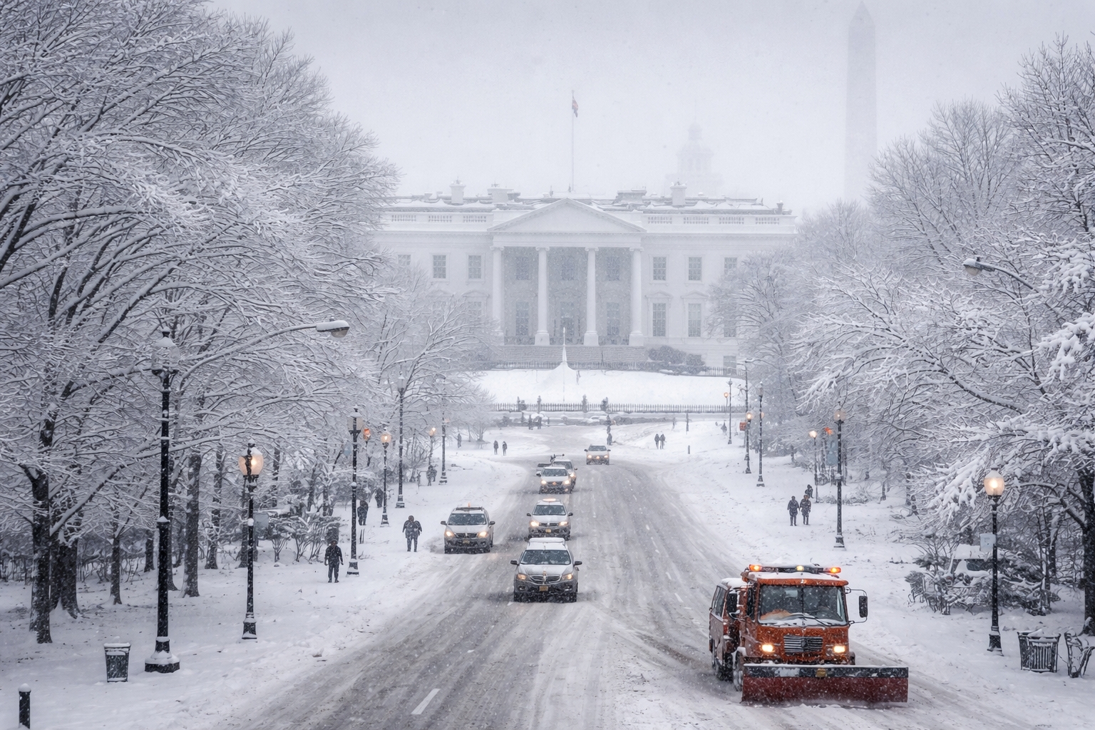
The Hotel Washington is positioned at the edge of the White House Lawn, making it the closest hotel to the White House. This location places guests within walking distance of essential landmarks and prioritized snow-removal routes, an important advantage when storms disrupt transportation.
For travelers navigating DC during winter weather, central location reduces reliance on transit systems and minimizes exposure to hazardous road conditions.
Experiencing Washington DC After the Storm
Winter storms often leave behind a transformed city. Snow-covered monuments, quiet streets, and a slower pace create a rare atmosphere that many visitors never experience.
The aftermath of a winter storm offers:
-
Reduced crowds at museums and landmarks
-
Unique photography opportunities
-
A calmer, more reflective cityscape
For travelers prepared to embrace winter conditions, Washington DC reveals a different side of its character.
Current Winter Storm Outlook: January 24 2026
The weekend of January 24 2026 finds Washington DC bracing for a winter storm that meteorologists describe as the biggest in a decade. Driven by an Arctic air mass pushing across North America and a coastal low developing off the Mid‑Atlantic, the system promises heavy snow, sleet and freezing rain across the region. Public officials have declared states of emergency in the District, Maryland and Virginia, and residents and visitors are being asked to complete their storm preparations early. The storm is expected to impact operations in the nation’s capital for several days, making this weather event a significant concern for travelers, commuters and those staying near the White House.
Bone‑chilling temperatures will linger throughout the weekend, with highs struggling to reach the low 20s and wind‑chill readings dipping well below zero. Light snowfall may begin after 9 p.m. Saturday, but heavy snow is forecast to fall overnight into Sunday. The National Weather Service projects 5–10 inches of snow for the immediate DC metro area, with some locations facing 12–14 inches and a thin layer of ice. These projections have triggered winter storm warnings through early Monday and contributed to widespread concern about travel and power disruptions.
Forecast Timeline and Expectations
-
Saturday (Daytime) – Cold and dry with highs in the upper teens to low 20s; morning wind chills below zero. Residents and visitors should finish storm preparations and avoid last‑minute errands later in the day.
-
Saturday Night – Snow begins late evening and intensifies before midnight. Heavy snow continues through sunrise Sunday, laying down several inches by morning. Temperatures drop into the teens with wind chills near zero.
-
Sunday – Moderate to heavy snow in the morning transitions to a wintry mix of sleet and freezing rain by afternoon, especially south of the city. Areas north of DC could see all snow and the highest totals. Travel may be nearly impossible at times and power outages are possible where ice accumulates.
-
Monday – The storm ends but bitter cold persists, leaving snow and ice on roadways. Sunshine provides little relief as highs remain in the 20s and gusty winds create a chill. Snow melt is minimal, and hazardous conditions continue.
Trending Questions Answered
How much snow will fall? The National Weather Service forecasts 5–10 inches for central Washington DC, with some areas potentially seeing up to 14 inches and a glaze of ice.
When does the snow start? Light snow could begin after 9 p.m. on Saturday, with heavy snow developing after midnight and continuing into Sunday morning.
Is this the biggest storm in years? Weather analysts describe this system as the largest snowstorm in a decade, bringing conditions reminiscent of previous Snowmageddon events.
By providing clear timeline information and referencing official forecasts, this section aligns with informational search intent while appealing to conversational queries such as “how much snow will DC get” and “when will the snow start in DC.”
State of Emergency and City Preparations
Washington DC’s mayor, Muriel Bowser, declared a State of Emergency as the storm approached, triggering a Snow Emergency that started at noon on Saturday, January 24 and remains in effect until the morning of Tuesday, January 27. During a snow emergency, motorists are prohibited from parking on designated snow emergency routes, and vehicles parked on these routes can be ticketed and towed. The declaration allows the District to access additional resources, including National Guard vehicles, to support first responders and emergency operations.
According to the District’s Department of Public Works (DPW), the National Weather Service projects at least nine inches of snow in Washington DC, with over a foot possible and freezing rain likely during the storm. The DPW warns that temperatures will remain below freezing through at least Wednesday, with wind‑chill values below zero. Residents and visitors are urged to limit outdoor exposure, sign up for AlertDC notifications and help neighbors experiencing homelessness find shelter.
How the City and Region Are Preparing
-
Snow Emergency Routes – Motorists must move vehicles off snow emergency routes before the storm. A map of these routes is available from the District at snow.dc.gov .
-
Plow Deployment – More than 300 heavy and light plows are being deployed across the District, and additional equipment is staged for priority corridors.
-
State and Regional Coordination – Virginia, Maryland and DC have all declared states of emergency, and the Virginia Department of Transportation (VDOT) reports that it has pre‑treated 14,000 lane miles of roadway and is staging snowplow crews across Northern Virginia.
-
Hypothermia Shelters – The District has opened extended‑hours hypothermia shelters and low‑barrier shelters for residents needing warmth during the storm.
-
Cold Weather Safety – Officials urge residents to stay indoors, layer clothing when outside, check on vulnerable neighbors, and use caution with space heaters.
Trending Questions Answered
What is a snow emergency? A snow emergency is a period during which parking is prohibited on designated routes so that plows can clear snow. For this storm, the snow emergency began at noon on January 24 and remains in effect until Tuesday morning.
Do I have to move my car? Yes. Vehicles parked on snow emergency routes after the deadline risk ticketing and towing. Use the official map to find alternative parking locations.
How is the city preparing? DPW and partner agencies have pre‑treated streets, deployed plows and opened shelters, while the Mayor has requested National Guard support.
This section serves informational and commercial investigation intents by outlining government actions, explaining the snow emergency rules and answering common questions about preparations.
Travel Impact and Navigating the Storm
As the storm unfolds, travel in and around Washington DC will become increasingly difficult. Transportation agencies have issued clear warnings: once snow begins, avoid unnecessary travel and give snowplows plenty of space. Local streets and bridges—particularly Canal Road, Foxhall Road, Key Bridge and Memorial Bridge—are expected to ice over quickly and may be treacherous. Even the Mall area, usually a popular destination for winter recreation, could be impassable at times.
The Virginia Department of Transportation reports that plow crews will stage along major routes and that clearing neighborhood streets may take days after the storm. Reduced visibility, drifting snow and the possibility of freezing rain will combine to create hazardous driving conditions, and officials caution against overconfidence; all‑wheel‑drive vehicles are not invincible on ice.
Navigating Transportation During the Storm
-
Avoid Driving Once Snow Begins – VDOT urges drivers to stay off the roads once snow starts falling so that crews can clear the highways and prevent accidents.
-
Expect Reduced Transit Service – Metro rail and bus services typically run on modified schedules during significant snow events. Check for updates before traveling.
-
Flight Disruptions – Flights at Ronald Reagan Washington National Airport, Washington Dulles International Airport and Baltimore Washington International Airport may experience delays or cancellations during heavy snow and ice. Monitor airline alerts and consider rescheduling travel around the storm.
-
Dangerous Roads and Bridges – Bridges freeze before roads. Key Bridge, Memorial Bridge and smaller downtown streets may become sheets of ice. Use extreme caution if travel is unavoidable.
-
Prepare Emergency Kits – Carry blankets, water, food, flashlights and a full tank of gas if you must drive. Keep your phone charged and inform someone of your route.
Trending Questions Answered
Which roads are the most dangerous? According to traffic experts, roads like Canal Road, Foxhall Road, Key Bridge and Memorial Bridge can turn icy quickly during Snowmageddon, making them especially hazardous.
Are flights canceled? Airlines anticipate delays and cancellations because heavy snow and ice will affect runways and de‑icing operations. Check directly with your airline and be prepared for itinerary changes.
Can I go sledding on the National Mall? Officials advise staying off the Mall during this storm because conditions will be treacherous and plows need room to operate.
These travel and safety tips address both informational and practical search intents, helping visitors and locals make informed decisions during the storm.
After the Storm and Future Patterns
While attention is focused on the January 24–26 storm, forecasters emphasize that this event is part of a larger pattern. Meteorologists at Arcfield Weather explain that an Arctic air outbreak will swallow much of the eastern United States, setting the stage for heavy snow in the DC–Philadelphia–New York corridor. Preliminary estimates call for 8–14 inches of snow in many areas, but sleet and freezing rain could limit accumulations. After the storm, bitter cold will continue, with morning lows possibly dipping below zero—a rarity in Washington DC since 1994.
In the days following the storm, surface temperatures will remain below freezing, making snow melt difficult. Frozen precipitation may stick around for much of the week. Forecasters also hint at the possibility of another major storm at the end of the month around January 31 or February 1.
Key Takeaways and Looking Ahead
-
Extended Cold – Expect morning temperatures below zero and wind‑chill values even lower in the week after the storm.
-
Long‑Lasting Snow Cover – Snow and ice will linger on roads and sidewalks due to persistent subfreezing temperatures.
-
Future Storm Potential – Forecast models suggest another winter storm could develop along the East Coast around Jan 31–Feb 1. Travelers should stay alert to updates.
-
Historical Context – The last time Washington DC recorded sub‑zero temperatures was in January 1994; this event could be similarly cold.
Trending Questions Answered
Will there be another storm after this one? Forecasters note the potential for another major storm around January 31–February 1 2026, though details remain uncertain.
How cold will it get? The Arctic air mass could push temperatures below zero, with wind‑chill values far below that. Sub‑zero readings in DC are rare; the last occurred in 1994.
How long will the snow last? Because temperatures will remain below freezing, snow and ice may persist for days after the storm ends.
This closing section offers broader context, satisfying informational and forward‑looking search intents while connecting the current storm to larger climate patterns.
For travelers navigating Washington DC during the January 2026 snowstorm, location and preparedness are crucial. The Hotel Washington—the closest hotel to the White House, located at the edge of the White House Lawn—provides a secure base near key government corridors and snow‑clearing priority routes. Plan your stay and explore available accommodations and winter travel offers at The Hotel Washington, and enjoy peace of mind knowing you’re within walking distance of major landmarks and essential services even when the city is blanketed in snow.
Planning Ahead for Winter Weather in Washington DC
Winter storms are an inevitable part of Washington DC’s climate, but they do not have to derail travel plans. With informed preparation, flexible scheduling, and strategic lodging choices, visitors can navigate winter weather confidently.
Choosing accommodations near the White House ensures access, safety, and continuity even when storms disrupt the broader region.
To plan your stay near the center of Washington DC during winter travel season, explore options and availability at
https://www.thehotelwashington.com
Entity References
| Entity Name | Type | Authoritative Source |
|---|---|---|
| Washington DC | City | https://www.dc.gov |
| National Weather Service | Federal Agency | https://www.weather.gov |
| Ronald Reagan Washington National Airport | Airport | https://www.flyreagan.com |
| Washington Dulles International Airport | Airport | https://www.flydulles.com |
| Baltimore Washington International Airport | Airport | https://www.bwiairport.com |
| White House | Federal Landmark | https://www.whitehouse.gov |
| National Mall | Federal Park | https://www.nps.gov/nama |