Names and Origins of Washington DC Neighborhoods
Washington DC is a mosaic of neighborhoods, each with a name that hints at a deeper story. From indigenous villages along the Anacostia River to grand Victorian subdivisions and streetcar suburbs, the city’s geography, politics and culture have shaped every district’s identity. While locals intuitively know where one neighborhood ends and another begins, visitors often wonder why a community is called Foggy Bottom or who Dupont Circle honors. This long‑form guide traces the etymology of each district, weaving together colonial land grants, Civil War forts, elite estates, universities and 20th‑century real‑estate ventures. By understanding the names, travelers gain insight into Washington’s urban evolution and the people who built it. Throughout the article you’ll find links to official sources and organizations, along with historical citations so that you can dig even deeper.
Early Capitals and Boundary Stones: Foundations of a City
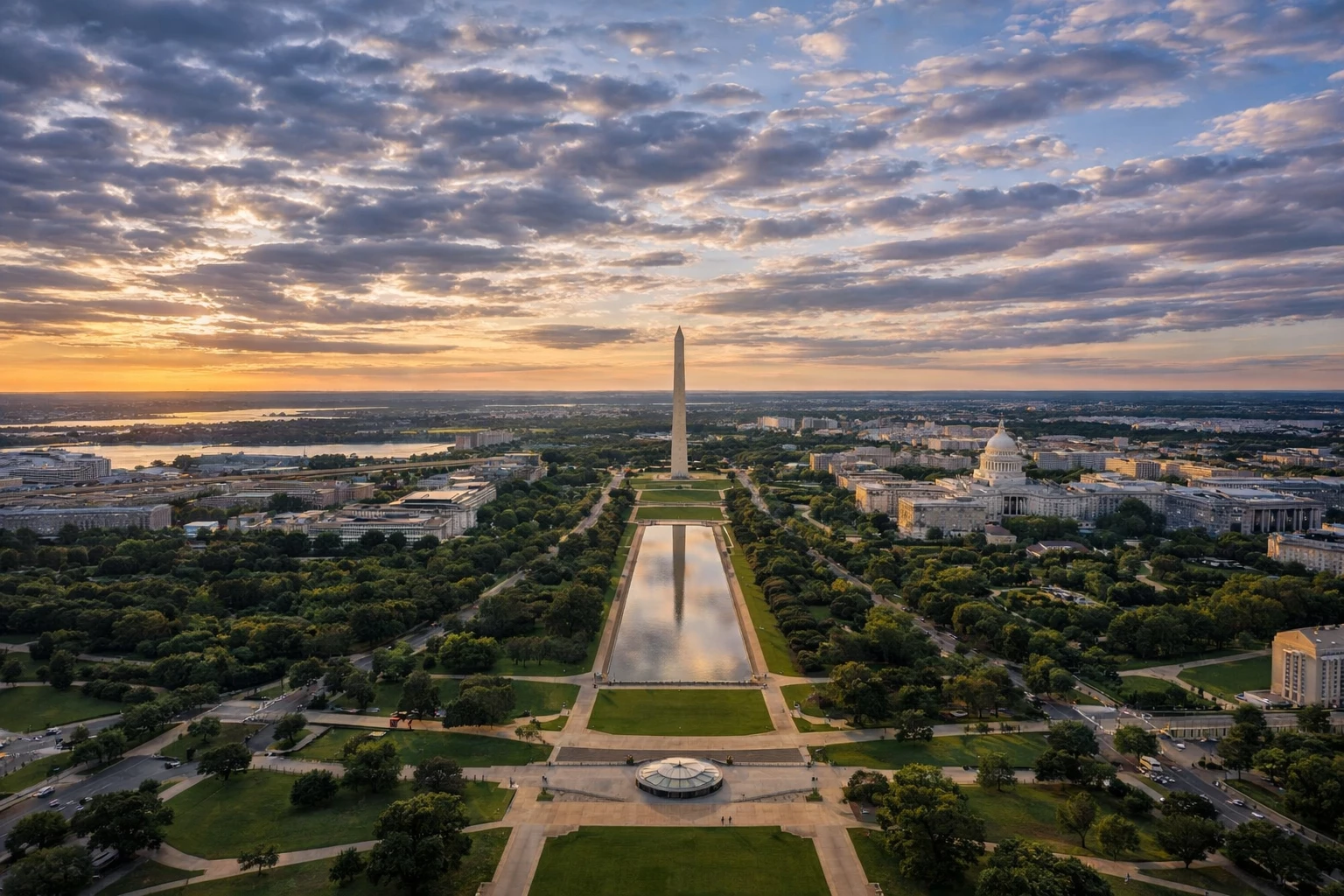
To appreciate Washington’s patchwork of neighborhoods, it helps to start with the city’s founding. After the United States chose a new federal capital along the Potomac River, surveyors laid out a diamond‑shaped District bounded by boundary stones. Pierre Charles L’Enfant’s 1791 Plan for the City of Washington organized the central core into broad avenues radiating from the U.S. Capitol and the White House. L’Enfant selected Jenkins’ Hill as the site for Congress because it provided “a pedestal worthy of the majestic dome”; the hill soon became known as Capitol Hill, anchoring a neighborhood whose identity revolves around the seat of government. Beyond the Federal City, farmland and estates stretched to the District line.
Colonial Settlements and Trade Ports
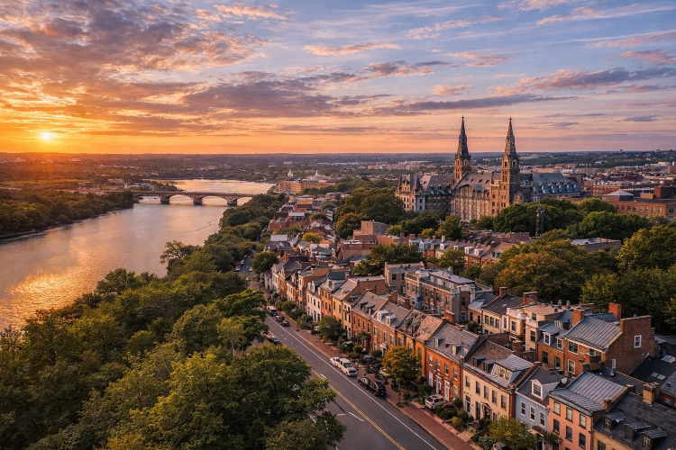
Before the new capital, colonial towns dotted the Potomac. Georgetown, chartered in 1751, predates Washington by decades. Some assume the port was named after George Washington, but historians note that he was still a young surveyor when Georgetown was established. It was likely named for either local landowners George Gordon and George Beall or King George II. The port thrived on tobacco exports and attracted merchants from across the Mid‑Atlantic. Across the river, indigenous peoples of the Nacotchtank or Anacostan tribe lived along the eastern shore. Their settlement, Anacostan or Anaquash, is the source of the name Anacostia—a word meaning a trading village or town. Centuries later, the neighborhood on the river’s east bank still bears this indigenous legacy.
Streets, Quadrants and Expansion
As the 19th century progressed, Washington expanded beyond the L’Enfant Plan. Boundary Street (today’s Florida Avenue) separated the original city from Washington County, where rural estates such as Pleasant Plains, Meridian Hill and Mount Pleasant dotted the landscape. The city’s streets were named alphabetically and numerically, while avenues honored states. The four quadrants—Northwest, Northeast, Southeast and Southwest—were defined relative to the Capitol. Neighborhoods often took the names of prominent families, geographic features, Civil War forts or later real‑estate developments. In the following sections, we explore these origins in detail.
Districts Named for People
Many Washington neighborhoods commemorate individuals who shaped national history or local development. Some honor military heroes, presidents and benefactors, while others reflect the complicated legacy of segregated institutions.
Dupont Circle: A Naval Hero in Stone and Bronze
In the heart of Northwest Washington, graceful townhouses encircle a traffic circle dominated by a fountain. The circle and fountain are named for Rear Admiral Samuel Francis Du Pont, who commanded Union naval forces during the Civil War. After the war, the government renamed a former traffic circle “Dupont Circle” to honor his service, and the sculptor Henry Bacon designed the marble fountain completed in 1921. Today the landscaped circle serves as a neighborhood gathering place and marks the center of one of Washington’s liveliest districts.
Adams Morgan: A Union of Segregated Schools
The eclectic, bohemian neighborhood of Adams Morgan lies just north of the White House. Its name is a deliberate combination of two segregated elementary schools: the all‑white John Quincy Adams Elementary School and the all‑black Thomas P. Morgan Elementary School. During the 1950s, community leaders used the schools’ names to symbolize an integrated neighborhood, and the moniker stuck. The Morgan School honored Thomas P. Morgan, a city commissioner and advocate for Black education, while the Adams School honored President John Quincy Adams. Today Adams Morgan’s nightlife, restaurants and art scene reflect this diverse heritage.
Shaw and the Legacy of Robert Gould Shaw
Immediately east of Adams Morgan lies Shaw, a neighborhood long associated with Black culture and activism. Urban planners defined the Shaw School Urban Renewal Area using the enrollment boundaries of Shaw Junior High School, which was named after Robert Gould Shaw, the white colonel who commanded the 54th Massachusetts Infantry Regiment, one of the first African‑American units in the Union Army. While Shaw himself died leading his troops at Fort Wagner, the neighborhood named in his honor became the cradle of “Black Broadway,” home to jazz clubs, theaters and civil‑rights activism along U Street. The name thus juxtaposes a white military officer’s sacrifice with the vibrant Black community that flourished there.
LeDroit Park: A Developer’s Tribute to Family
The tree‑lined enclave of LeDroit Park arose in the 1870s as one of Washington’s first planned suburbs. Its developer, Amzi Barber, was a founder of Howard University and a wealthy entrepreneur. Barber married LeDroict Langdon, and he honored his father‑in‑law by naming the neighborhood LeDroit Park, dropping the “c” from LeDroict’s surname. Initially an exclusive enclave for white residents, LeDroit Park was surrounded by a fence and guarded gates. African‑American residents tore down the fence in 1888, and by the early 20th century the community became racially integrated and home to notable Black educators and activists.
Cleveland Park: Presidential Leisure on a Hilltop
Northwest Washington’s Cleveland Park takes its name from President Grover Cleveland. Cleveland purchased a farmhouse called Oak View at this hilltop location as a summer residence. The local community began referring to the area as Cleveland Park, and the name stuck. The Cleveland Park Historical Society notes that the neighborhood was named to commemorate the president’s summer home. Today the area retains many of its late‑19th‑century residences and remains one of the city’s most desirable addresses.
Glover Park: Banking on Philanthropy
Located south of the National Cathedral, Glover Park honors banker and philanthropist Charles Carroll Glover. Glover served as president of Riggs Bank and helped fund the creation of Rock Creek Park and the National Zoo. The neighborhood, developed in the early 20th century, bears his name. Its location near the wooded slopes of Rock Creek and proximity to embassies make it a leafy enclave within the urban core.
Petworth: An English Namesake in Northwest DC
The residential district of Petworth traces its name to an estate owned by Revolutionary War veteran John Tayloe III. Tayloe’s 205‑acre property, called Petworth, likely honored the town of Petworth in West Sussex, England. In the late 19th century developers subdivided the land, and the neighborhood kept the estate’s name. Today Petworth is known for its rowhouses, Georgia Avenue commercial strip and family‑friendly vibe.
Carver Langston: Celebrating Black Innovators
In Northeast Washington, the neighborhood of Carver Langston recognizes two trailblazing African‑American figures. It combines the surnames of agricultural scientist George Washington Carver and lawyer and politician John Mercer Langston. Langston became the first dean of Howard University’s law school and later served as U.S. minister to Haiti, while Carver’s scientific achievements revolutionized agriculture. The combined name highlights the community’s roots in the 20th‑century movement to honor Black leaders.
Fort Totten: A Civil War Fort Turned Neighborhood
Named for the Civil War fort built in 1861 to protect President Abraham Lincoln’s summer residence at the Old Soldiers’ Home, Fort Totten commemorates Brigadier General Joseph Gilbert Totten, chief of engineers of the U.S. Army. The fort’s earthworks remain visible in the park north of the Metro station, and the neighborhood developed around the transportation hub. Street names like Fort Totten Drive preserve the military legacy.
Foxhall Village: Honoring an Arms Manufacturer
West of Georgetown, quaint Tudor houses line the winding streets of Foxhall Village. The area was once Spring Hill Farm, owned by industrialist Henry Foxall, who ran the Columbian Foundry in Georgetown and manufactured cannons during the War of 1812. A developer subdivided the property in 1908 and named it Foxall Heights in honor of its previous owner; later, a resubdivision created the current name Foxhall Village with an added “h”. The architectural style evokes English villages, blending perfectly with the name’s British roots.
Districts Named for Geography and Natural Features
Geographical features and descriptive phrases often inspire neighborhood names. Whether referencing rivers, hills or atmospheric conditions, these names ground neighborhoods in the natural landscape.
Anacostia: Indigenous Roots on the River
East of the Anacostia River, the neighborhood of Anacostia bears the name of the region’s original inhabitants. The Nacotchtank or Anacostan people lived along the river and built a trading village called Anaquash or Anacostan. The word Anacostia derives from this Nacotchtank term meaning a village or trading center. The community later grew around the bridge crossing the river and the marine base at 8th Street. Today Anacostia is known for historic homes and the Frederick Douglass National Historic Site.
Kalorama: Greek for “Beautiful View”
Few neighborhood names are as lyrical as Kalorama. When poet and diplomat Joel Barlow purchased a mansion northwest of Dupont Circle in 1807, he christened the estate Kalorama—Greek for “beautiful view.” The name suited the property’s sweeping vistas of Rock Creek Park and the Potomac River. Over time the estate’s name came to designate the surrounding neighborhood, now divided into Sheridan‑Kalorama and Kalorama Triangle. The word’s Greek origin underscores the area’s elegance and diplomatic status.
Pleasant Plains and Mount Pleasant: From Estate to Suburb
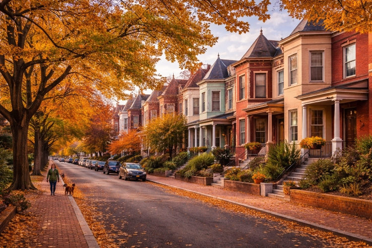
In the 18th century, planter James Holmead received a land grant east of Rock Creek. His son Anthony Holmead named the tract Pleasant Plains, a pastoral description that eventually applied to the surrounding area. During the Civil War era, entrepreneur Samuel Brown purchased a portion of the land between 14th and 17th Streets. He built a house there and, after selling off adjacent parcels, named his property Mount Pleasant Village because it encompassed the highest point of the Pleasant Plains estate. Today Pleasant Plains remains a small neighborhood adjacent to Howard University, while Mount Pleasant evolved into a diverse, tree‑lined district known for its 19th‑century rowhouses and vibrant Latino community.
Foggy Bottom: A Marshy Moniker
Just west of the White House, low‑lying land along the Potomac once consisted of marshes and shallow river inlets. In the 19th century the area hosted breweries, gasworks and slaughterhouses whose smoke mingled with morning fog. Residents dubbed the area Foggy Bottom to describe the combination of mist and industrial fumes. The name stuck even as the neighborhood became home to George Washington University, the State Department and the Kennedy Center.
Palisades: Bluffs Above the Potomac
The Palisades neighborhood stretches along MacArthur Boulevard, where steep, wall‑like bluffs rise above the Potomac River. A 20th‑century real‑estate company marketed the area as “Palisades of the Potomac,” referencing these natural ramparts. A modern real‑estate guide notes that the Palisades is named after the wall‑like bluffs it sits on above the river. Today the Palisades retains a small‑town feel with local parades, community gardens and easy access to the C&O Canal towpath.
Park View: Vistas Toward the Soldiers’ Home
North of Howard University, the community now known as Park View was first subdivided in 1886 as Whitney Close. Development accelerated after streetcar lines and the McMillan Reservoir improved accessibility. In 1908 the Park View Citizens’ Association chose the name Park View because the neighborhood enjoyed views of the nearby U.S. Soldiers’ Home. Residents could look over Georgia Avenue toward the rolling lawns of the veterans’ home, and the name distinguished the area from adjacent subdivisions. Although high‑rise buildings now obscure the vistas, the neighborhood’s name endures as a reminder of its bucolic beginnings.
Trinidad: Named for a Caribbean Estate
Northeast of Gallaudet University lies Trinidad, a small neighborhood with a unique story. In the late 19th century, land speculator James Barry purchased farmland here and named his estate Trinidad after the Caribbean island. When developers subdivided the estate, the name carried over to the new community. Street names such as Montello and Trinidad Avenue reflect this exotic inspiration.
Swampoodle: A Lost District of Swamps and Puddles
East of Union Station once stood a neighborhood called Swampoodle. A low‑lying Irish enclave during the 19th century, it earned its colorful name from the swampy puddles that formed after heavy rains. When Union Station opened in 1907, the railroad tracks displaced the community, and today no trace remains except for stories and the occasional newspaper reference. Swampoodle’s demise reminds us how infrastructure reshaped the city and erased some neighborhood names.
Districts Named for Institutions and Landmarks
Universities, schools and churches have also bestowed their names on surrounding neighborhoods. These districts often grew from educational campuses or religious centers.
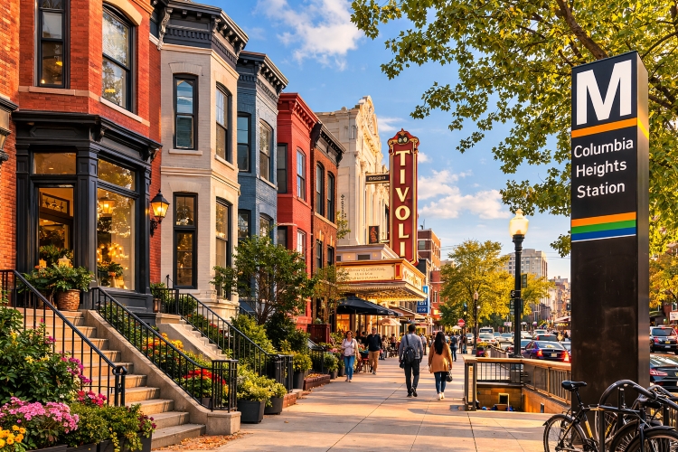
Columbia Heights: A University’s Legacy
Columbia Heights occupies a ridge north of downtown. Its name comes from Columbian College, a Baptist institution founded in 1821 that later became George Washington University. The college’s campus was located in this neighborhood during the 19th century, and the area became known as Columbia Heights. Streetcar lines spurred residential development, and by the early 20th century the neighborhood featured stately rowhouses and the landmark Tivoli Theater. Today Columbia Heights is one of DC’s most diverse areas, with Central American eateries, Ethiopian markets and a bustling Metro station.
Brookland: From Brooks Estate to “Little Rome”
Northeast Washington’s Brookland grew on land once owned by the Brooks family. After the Civil War, the family sold their estate to developers who created a housing tract called “Brookland”. The neighborhood later earned the nickname “Little Rome” because of the many Catholic institutions clustered along Michigan Avenue, including the Catholic University of America, the Basilica of the National Shrine of the Immaculate Conception and various monasteries. The combination of the Brooks family name and the area’s religious influence gives Brookland a distinctive identity.
Tenleytown: A Tavern Becomes a Town
Perched on one of the city’s highest points, Tenleytown traces its origins to a tavern. In 1790 locals began calling the area Tennally’s Town after tavern keeper John Tennally. Over the 19th century the spelling evolved to Tenleytown, and the community became a stopping point for travelers heading north along Wisconsin Avenue. Today Tenleytown is home to American University and a commercial corridor anchored by a Metro station.
Fort Totten and Other Civil War Forts
During the Civil War, a ring of forts protected Washington. Several neighborhoods still carry the fort names, including Fort Totten, Fort Stevens and Fort DuPont. The names honor generals, engineers or battle sites. Fort Totten commemorates General Joseph Gilbert Totten and protected President Lincoln’s summer cottage. Fort Stevens, in present‑day Brightwood, honors General Isaac Ingalls Stevens and was the site of the only Civil War battle fought in the District. Fort DuPont, in Southeast, is named after Rear Admiral Samuel Francis Du Pont and forms part of a large park.
Districts Named for Estates and Real‑Estate Ventures
Many Washington neighborhoods began as country estates or promotional ventures. Developers often selected pastoral or aspirational names to lure buyers to newly platted streets.
Friendship Heights: An Estate and a Station
At the District’s northern boundary, Friendship Heights straddles both Maryland and the District of Columbia. The area takes its name from Friendship, the country estate of newspaper magnate John R. McLean. According to the Village of Friendship Heights, the Friendship Station post office and subdivision were named for McLean’s estate. Early 20th‑century developers combined the subdivisions of Friendship Heights and The Hills into a special taxing area under the Friendship Heights name. Today the neighborhood features high‑rise offices and luxury retail, reflecting its evolution from farmland to commercial hub.
Woodley Park: An English Manor Inspires a Name
South of the National Zoo, Woodley Park was once the site of Woodley House, an estate built in 1801 by Philip Barton Key. Key named the mansion after an English estate called Woodley, and the house later housed politicians, generals and even a president. The surrounding neighborhood adopted the name Woodley Park, honoring the stately home that stood on its grounds. Today Woodley Park features embassies, hotels and rowhouses, and it provides access to the Smithsonian’s National Zoo.
Chevy Chase: A Land Company’s Branding
Stretching from northwest Washington into Maryland, Chevy Chase owes its name to the Chevy Chase Land Company. In the late 19th century Senator Francis Newlands and his partners formed the company to develop a suburban community along Connecticut Avenue. They adopted the name Chevy Chase from a 14th‑century English ballad about a border skirmish in the Cheviot Hills; the term “chevy chase” referred to hunting grounds. The land company marketed its neighborhood as an exclusive enclave, and the name stuck. Today Chevy Chase features leafy streets, single‑family homes and a commercial strip centered on Connecticut Avenue.
Foxhall and Palisades: Estates and Bluffs
The river‑adjacent enclave of Foxhall traces its name to industrialist Henry Foxall, whose estate occupied the area in the early 19th century. Developers later named the subdivision Foxall Heights and then Foxhall Village, preserving the Foxall family’s legacy. Adjacent to Foxhall, the Palisades neighborhood took its name from the high bluffs along the Potomac—natural palisades that developers used as a marketing hook. Both communities retain a village atmosphere despite their proximity to downtown.
Mount Pleasant and Pleasant Plains: Country Estates Turned Communities
The story of Mount Pleasant illustrates how estate names morph into neighborhood identities. James Holmead’s Pleasant Plains estate covered much of today’s Ward 1. After the Civil War, Samuel Brown bought a portion of the property and, because his home sat on the estate’s highest ground, named his subdivision Mount Pleasant Village. Over time the name Mount Pleasant applied to a larger area west of 16th Street, while Pleasant Plains remained the designation for land east of Georgia Avenue near Howard University.
Petworth, Glover Park and Palisades: From Estates to Streets
In addition to Petworth’s roots in John Tayloe’s estate and Glover Park’s tribute to banker Charles Glover, many other neighborhoods owe their names to estates or real‑estate ventures. The small subdivision of Truxton Circle, for example, commemorated a traffic circle (no longer extant) named after naval hero Commodore Thomas Truxtun. Spring Valley, in upper Northwest, was developed by the W.C. & A.N. Miller Company and named for its rolling terrain and natural springs. Crestwood conjures images of a ridge lined with trees, while American University Park references the nearby university. Although not every name’s origin is formally documented, the common theme is marketing suburban ideals to potential buyers.
Quadrant Stories: Exploring DC by Direction
Washington’s four quadrants—Northwest, Northeast, Southeast and Southwest—contain distinct clusters of neighborhoods. Understanding quadrant boundaries helps visitors navigate and appreciate the city’s diversity.
Northwest: Historic Districts and Diplomatic Enclaves
Northwest DC, the largest and most affluent quadrant, includes many of the city’s historic neighborhoods. Georgetown, with its cobblestone streets and Federal‑era rowhouses, was once an independent port and may have been named for local landowners or King George II. Up Connecticut Avenue, the streetcar suburbs of Woodley Park, Cleveland Park, Chevy Chase and Friendship Heights reflect the city’s early 20th‑century expansion. Northwest also hosts diplomatic districts like Kalorama, where embassies line Sheridan Circle. Adams Morgan, Shaw and U Street showcase the city’s multicultural energy with restaurants, jazz clubs and murals honoring civil‑rights leaders. The Palisades and Foxhall neighborhoods along the Potomac offer quiet streets and views of the river bluffs.
Northeast: Education and Faith
Across North Capitol Street, Northeast DC houses the Catholic University of America, Gallaudet University and the Brookland Arts Walk. Neighborhoods like Brookland (named after the Brooks estate) and Michigan Park grew around these campuses. Trinidad, named after James Barry’s Caribbean‑inspired estate, sits near the H Street Corridor and the streetcar line. The Carver Langston neighborhood memorializes George Washington Carver and John Mercer Langston. Northeast’s mix of rowhouses, industrial lofts and green spaces reflects its working‑class roots and ongoing revitalization.
Southeast: Riverfront Heritage
Southeast DC hugs the Anacostia River and includes both Capitol Hill and historic Black communities. The Navy Yard grew around the Washington Navy Yard, established in 1799, and today features waterfront parks and baseball stadiums. Anacostia, named for the Nacotchtank settlement, preserves 19th‑century houses on Cedar Hill where Frederick Douglass lived. Hillcrest and Fort Dupont reflect mid‑20th‑century suburbanization, while Congress Heights takes its name from its position atop a ridge south of Congress’s seat.
Southwest: From Wharf to Wharf
Washington’s smallest quadrant, Southwest, has undergone dramatic transformation. Historically known for the Southwest Waterfront and Buzzard Point, the area once contained rowhouses and fish markets. In the mid‑20th century, urban renewal razed much of Southwest, replacing it with modernist apartment complexes. Recent redevelopment at The Wharf has revived the waterfront with restaurants, music venues and marinas, though the old neighborhood names linger in memories and street names. A few blocks inland, Southwest Federal Center includes Smithsonian museums along the National Mall.
Cultural Significance and Neighborhood Identity
While names reveal origins, neighborhood identities evolve through cultural expression, activism and migration. U Street—running east from 14th Street to the Howard Theatre—earned the nickname “Black Broadway” for its concentration of jazz clubs, theaters and Black‑owned businesses during the early 20th century. In the 1920s and 1930s, legends like Duke Ellington and Pearl Bailey performed here. Nearby Shaw and LeDroit Park provided housing and civic institutions for Black professionals when segregation limited options elsewhere.
Several neighborhoods host distinct cultural enclaves. Along 9th Street in Shaw, Little Ethiopia features Ethiopian restaurants and markets. Chinatown, centered on 7th and H Streets NW, formed in the 1930s when Chinese immigrants relocated from Pennsylvania Avenue and built the ornate Friendship Archway. Brookland’s concentration of Catholic institutions earned it the nickname Little Rome. These clusters illustrate how migration patterns infuse neighborhoods with new identities while the names remain constant.
Neighborhood names also highlight Washington’s history of segregation and activism. The creation of Adams Morgan symbolized a post‑Brown v. Board of Education commitment to integration. Park View residents fought to integrate their playground and schools in the mid‑20th century, reflecting the broader civil‑rights movement. In Shaw, community leaders preserved historic buildings and established heritage trails honoring African‑American educators, soldiers and artists. Names like Carver Langston memorialize Black excellence, while Swampoodle reminds us of marginalized immigrant communities displaced by urban development.
Visiting Washington’s Neighborhoods Today
Exploring Washington by neighborhood offers a richer experience than limiting yourself to museums and monuments. Start in Capitol Hill, where you can tour the U.S. Capitol’s Rotunda and the Library of Congress. Stroll east to Eastern Market, a 19th‑century public market buzzing with farm stands and artisans. Head north to Dupont Circle—honoring Admiral Du Pont—to enjoy coffee shops, bookstores and a weekly farmers’ market. Walk through Kalorama to see embassy mansions and the Woodrow Wilson House.
Cross Rock Creek Park to visit Adams Morgan, where rowhouses painted in bright colors host jazz clubs and pan‑Latin restaurants. Continue north to Mount Pleasant, where you can admire century‑old rowhouses and enjoy Salvadoran pupusas; remember that Samuel Brown named the area because his home sat on the high point of Pleasant Plains. East of Meridian Hill Park, wander through Columbia Heights, a neighborhood named after Columbian College and now known for its global cuisine.
Northeast, explore Brookland, visiting the Basilica of the National Shrine of the Immaculate Conception and Catholic University. Stop in Fort Totten Park to see Civil War earthworks and appreciate General Totten’s legacy. West of the river, ride or bike along the Capital Crescent Trail in the Palisades, and finish with a sunset at Georgetown’s waterfront, reflecting on whether the name honors King George II or local landowners.
When choosing lodging, proximity matters. Hotel Washington, the closest hotel to the White House positioned at the edge of the White House lawn, provides convenient access to many neighborhoods. From its rooftop bar you can look south toward the monuments and east toward Capitol Hill, then set off to explore Foggy Bottom’s museums or catch a show on U Street. Washington’s neighborhoods are best enjoyed at a leisurely pace—one stroll, coffee or conversation at a time.
Frequently Asked Questions
-
How did Foggy Bottom get its name? – The neighborhood lies in a low area where early industries spewed smoke. Combined with morning fog from the Potomac, this created a “foggy bottom”.
-
Who is Dupont Circle named after? – The traffic circle and fountain honor Rear Admiral Samuel Francis Du Pont, a Union naval commander.
-
What is the origin of Anacostia’s name? – The word comes from the Nacotchtank or Anacostan people’s term for their trading village along the river.
-
Why is Adams Morgan called Adams Morgan? – It combines the names of two segregated schools—John Quincy Adams Elementary and Thomas P. Morgan Elementary—to symbolize integration.
-
Why is Mount Pleasant named Mount Pleasant? – Samuel Brown named his subdivision Mount Pleasant because his house sat on the highest part of the Pleasant Plains estate.
-
What does Kalorama mean? – Kalorama is Greek for “beautiful view,” a name given by poet Joel Barlow to his estate.
-
Who were Carver Langston? – The neighborhood combines the surnames of scientist George Washington Carver and lawyer John Mercer Langston.
-
Why is Tenleytown called Tenleytown? – It derives from “Tennally’s Town,” named for tavern keeper John Tennally in the late 18th century.
People Also Ask
What are the neighborhoods of Washington DC and how did they get their names?
Washington DC neighborhoods were named after historical figures, geographic features, estates, universities, and Civil War forts. Examples include Georgetown, named for colonial landowners or King George II; Dupont Circle, named after Admiral Samuel Francis Du Pont; and Mount Pleasant, named for its location on the highest part of the Pleasant Plains estate.
How many neighborhoods are there in Washington DC?
Washington DC has more than 130 recognized neighborhoods. Each developed from farmland, estates, villages, or military sites that were gradually incorporated into the growing capital city during the 19th and 20th centuries.
Why is Georgetown called Georgetown?
Georgetown was founded in 1751 and was likely named after either King George II of Great Britain or two early landowners named George Gordon and George Beall. It was an important tobacco port before Washington DC became the national capital.
Why is Dupont Circle named Dupont Circle?
Dupont Circle is named after Rear Admiral Samuel Francis Du Pont, a Union naval officer during the Civil War. The traffic circle and its marble fountain were built to honor his contributions to the Union Navy.
Why is Adams Morgan called Adams Morgan?
Adams Morgan combines the names of two former schools in the neighborhood: John Quincy Adams Elementary School and Thomas P. Morgan Elementary School. The name symbolized racial integration after the schools were desegregated in the mid-20th century.
What does Kalorama mean in Washington DC?
Kalorama comes from a Greek word meaning beautiful view. The name was given to a hilltop estate by poet and diplomat Joel Barlow in the early 1800s, and the surrounding neighborhood eventually adopted the same name.
Why is Foggy Bottom called Foggy Bottom?
Foggy Bottom was named for the combination of natural river fog from the Potomac and smoke from nearby factories, breweries, and industrial buildings during the 19th century. The low-lying area often appeared foggy or smoky.
Why is Mount Pleasant called Mount Pleasant?
Mount Pleasant was named by Samuel Brown in the late 1800s because his home sat on the highest point of the Pleasant Plains estate. The name referred to the elevated and scenic location.
Why is the Palisades neighborhood called the Palisades?
The Palisades neighborhood takes its name from the steep cliff-like bluffs overlooking the Potomac River. These natural formations resemble defensive walls known as palisades.
Why is Petworth called Petworth?
Petworth was originally the name of a large country estate owned by John Tayloe III. The estate was likely named after the town of Petworth in West Sussex, England. Developers kept the name when the land was subdivided.
Why is Glover Park named Glover Park?
Glover Park is named after Charles Carroll Glover, a banker and philanthropist who helped fund the creation of Rock Creek Park and other public green spaces in Washington DC.
What does the name Anacostia mean?
Anacostia comes from the name of the Nacotchtank or Anacostan Native American tribe who lived along the river before European settlement. The word refers to their trading village along the Anacostia River.
Why is Park View called Park View?
Park View received its name in 1908 because the neighborhood had views of the nearby U.S. Soldiers’ Home grounds. Residents chose the name to highlight the surrounding green space.
Why is Tenleytown called Tenleytown?
Tenleytown was originally called Tennally’s Town, named after tavern owner John Tennally who operated an inn there in the late 1700s. The spelling gradually evolved to Tenleytown over time.
What is the origin of Columbia Heights in Washington DC?
Columbia Heights is named after Columbian College, the institution that later became George Washington University. The college operated in the neighborhood during the 19th century.
Closing Thoughts
Washington’s neighborhood names preserve layers of history—from indigenous languages and colonial estates to Civil War fortifications and 20th‑century urban renewal. Understanding these origins enriches every walk through the city. As you explore, remember that no two neighborhoods are alike: each evolved from its own confluence of people, place and purpose. Whether you’re savoring Ethiopian coffee in Shaw, listening to jazz on U Street or watching the sunset from Georgetown’s waterfront, you are walking through stories centuries in the making. After your adventures, consider unwinding at Hotel Washington at 15th Street and Pennsylvania Avenue—just steps from the White House lawn and a perfect starting point for your next neighborhood journey.
Read other posts