Washington DC Metro: A Complete Guide to the Capital’s Rail Lifeline
Washington’s Metrorail system is more than a way to get from point A to point B. Since its opening in 1976, the Metro has shaped commuting patterns, fueled economic growth and connected millions of visitors with the monuments, museums and neighborhoods that define the nation’s capital. In 2025 alone, Metro riders took 264 million trips and rail ridership reached 139 million journeys–record numbers for a transit agency still emerging from pandemic‑era declines. With 98 stations spread across six color‑coded lines and operating hours that stretch from early morning until after midnight, the Metro remains the region’s indispensable mobility backbone. This guide introduces the system’s history, lines, fares, schedules, trip‑planning tools and etiquette and shows how Metrorail offers seamless access to landmarks, airports and neighborhoods–all while highlighting the unique advantages of staying at Hotel Washington, the closest hotel to the White House, positioned at the edge of the White House Lawn.
Origins and evolution of the Metrorail system
Rising above gridlock and harnessing local ambition, the Washington Metro emerged from a mid‑20th‑century debate between building freeways or investing in transit. Planning started in the 1960s after the creation of the Washington Metropolitan Area Transit Authority (WMATA); groundbreaking occurred in 1969, and the first segment of the Red Line debuted in 1976. Over the next five decades, the network expanded into Maryland and Virginia, reaching outlying communities like Shady Grove, Branch Avenue and Franconia‑Springfield. The architecture of early stations–vaulted concrete cathedrals lit by soft indirect light–exudes a timeless futuristic aesthetic. WMATA’s commitment to growth continued into the 21st century with large‑scale projects such as the Silver Line to Tysons, Reston and Loudoun County and the long‑anticipated Potomac Yard infill station in Alexandria, which opened on May 19 2023 and became the system’s 98th station.
By fiscal year 2025, Metro was not only celebrating record ridership but also announcing savings of $120 million and operational innovations such as the Tap. Ride. Go. contactless payment program and the reintroduction of automatic train operation. These milestones attest to a system that adapts to shifting commuter patterns, modernizes fare collection and pursues new expansions despite funding challenges. Looking ahead, WMATA plans to extend Yellow Line trains to Greenbelt and continue exploring long‑range projects, including a potential Blue Line Loop that would link underserved corridors in Southeast D.C. and Prince George’s County.
Designing a cathedral for commuters
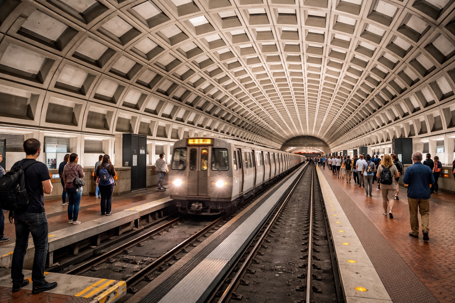
Metro’s early planners recognized that the system’s architecture could shape the way people feel about public transit. Instead of installing a forest of utilitarian columns and beams like many older subways, Chicago‑based architect Harry Weese conceived of stations as civic spaces with soaring coffered vaults. These barrel‑vaulted ceilings, built of precast concrete segments and lit indirectly from below the spring lines, create a calm, cathedral‑like atmosphere. Weese felt that dignified architecture would encourage riders to be respectful of their surroundings and of one another. His design also echoed Washington’s neoclassical heritage, using a modern material palette to achieve the monumentality associated with the city’s public buildings.
The decision to build such refined spaces was not aesthetic indulgence but part of a broader political compromise. In the 1950s and ’60s, federal and local officials proposed a network of radial highways that would have razed whole neighborhoods. Community activists, both Black and white, fought the freeway plans and demanded a transit alternative that would preserve housing and knit the city together. The architecture of the stations–the unpainted concrete, gentle lighting and vaults that span entire platforms–became a symbol of this citizen‑driven vision. As the network expanded, engineers adapted the vaulted design to fit different site conditions; stations like Dupont Circle and Foggy Bottom have deep vaults with mezzanines perched above the tracks, while shallow stations such as Columbia Heights incorporate skylights that bring daylight underground.
A timeline of milestones
Metro’s growth unfolded in stages, each shaped by funding and regional politics. Key milestones include:
-
1967–1969: WMATA is established and acquires the bankrupt DC Transit bus system. Construction of the rail network begins with downtown tunnels and the Red Line.
-
March 1976: The first 4.6‑mile segment opens between Farragut North and Rhode Island Avenue on the Red Line. The initial stations showcase the coffered vaults that become Metro’s signature.
-
1977–1990: Additional segments extend service to Shady Grove, Glenmont, Vienna, Huntington and Addison Road. The Orange and Blue lines are completed, linking suburban Virginia and Maryland to the District.
-
1991: The Green Line begins limited service, gradually extending to Greenbelt by 2001.
-
2004: The Blue Line reaches Largo Town Center, providing rail access to Prince George’s County.
-
2014–2022: The Silver Line opens in two phases, first to Wiehle–Reston East and later to Ashburn, via Washington Dulles International Airport. This 23‑mile extension connects rapidly growing communities in Fairfax and Loudoun counties.
-
May 2023: Potomac Yard station debuts between Reagan National Airport and Braddock Road, marking the first infill station added to the system and anchoring new development in Alexandria.
-
Coming years: WMATA pursues the Yellow Line extension to Greenbelt, station upgrades, and studies for a Blue Line Loop and new Georgetown link that could knit previously unserved neighborhoods into the network.
Each opening reshaped commuting patterns and spurred economic development near stations. The arrival of rail in Arlington’s Rosslyn–Ballston corridor catalyzed a boom in walkable, mixed‑use districts; new towers and retail sprang up near stops such as Clarendon and Ballston, turning former car‑oriented strip malls into thriving urban centers. In Maryland, stations at Silver Spring and Bethesda attracted biotechnology firms, film festivals and high‑density housing. Across the Potomac, the Orange Line’s suburban terminus in Vienna anchored park‑and‑ride facilities that allow Fairfax County residents to commute car‑free to downtown jobs.
The Great Society Subway’s legacy
Historian Zachary Schrag, author of The Great Society Subway, notes that the Metro was conceived in the spirit of President Johnson’s Great Society programs, combining infrastructure investment with social equity. The system not only provided an alternative to highway construction but also committed to fare structures that balanced cost recovery with accessibility. Over the decades, Metro has weathered financial crises, maintenance backlogs and even tragic accidents, yet it remains a unifying project that underpins the capital region’s economic vitality and symbolizes the federal commitment to public transportation.
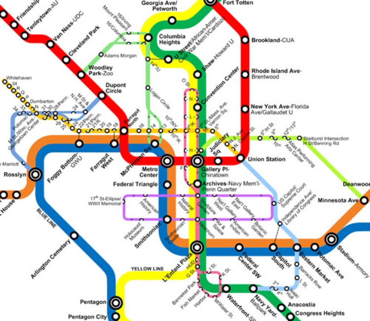
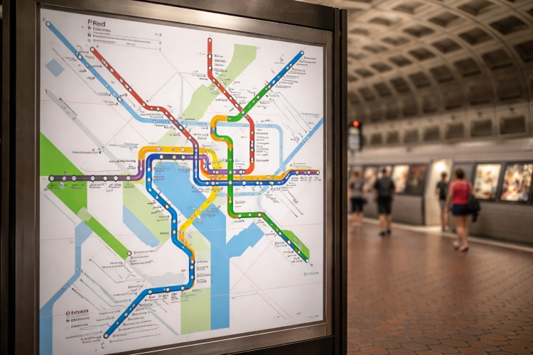
Understanding Metro’s color‑coded lines and key stations
Six color‑coded rail lines–Red, Orange, Silver, Blue, Yellow and Green–form the backbone of Metrorail, allowing riders to traverse the Washington region with no more than a single transfer. Each line has its own character and serves a mix of government centers, historic neighborhoods and suburban hubs. The table below lists the lines, their termini and notable stations, highlighting those near major attractions. Use it as a quick reference when planning your journey. Note that transfer stations are bolded and stations near top sites are italicized.
| Line | Termini | Major stops (transfer stations bolded; attractions italicized) |
|---|---|---|
| Red | Shady Grove ↔ Glenmont | Metro Center, Gallery Place‑Chinatown, Union Station, Woodley Park–Zoo/Adams Morgan (near National Zoo), Dupont Circle, Bethesda |
| Orange | Vienna ↔ New Carrollton | Rosslyn, L’Enfant Plaza, Metro Center, Smithsonian (gateway to the National Mall), Eastern Market, Stadium‑Armory |
| Silver | Ashburn ↔ Largo Town Center | Rosslyn, Metro Center, L’Enfant Plaza, Tysons, Reston Town Center, Dulles International Airport |
| Blue | Franconia‑Springfield ↔ Largo Town Center | Rosslyn, L’Enfant Plaza, Metro Center, Pentagon, Arlington Cemetery, Ronald Reagan Washington National Airport |
| Yellow | Huntington ↔ Mt Vernon Sq*/*Greenbelt (service pattern varies) | L’Enfant Plaza, Gallery Place‑Chinatown, Pentagon, Archives‑Navy Memorial, Columbia Heights, Fort Totten |
| Green | Branch Avenue ↔ Greenbelt | L’Enfant Plaza, Gallery Place‑Chinatown, Fort Totten, Smithsonian, Navy Yard–Ballpark, U Street, College Park–U of Md |
Line‑by‑line overview
The six color‑coded lines each have their own identity, shaped by geography, history and the communities they serve. Understanding the character of each route helps visitors choose where to explore and appreciate how the network knits together disparate corners of the region.
Red Line: the north–south backbone
The Red Line is Metrorail’s original spine and remains its busiest route. Running in a crescent from Shady Grove in Montgomery County through downtown to Glenmont in eastern Silver Spring, it serves major employment centers, universities and historic neighborhoods. At its suburban termini, park‑and‑ride lots allow commuters to leave their cars behind, while inner‑city stations like Dupont Circle and Woodley Park–Zoo/Adams Morgan offer access to nightlife, embassies and the National Zoo. At Wheaton, riders encounter the system’s longest escalators, stretching 230 feet and ranked among the longest in the Western Hemisphere–a thrilling ascent or descent that hints at the depth of Washington’s geology. Further north, Twinbrook, Rockville and Shady Grove support suburban job clusters and are linked to MARC commuter rail service.
Orange Line: cross‑Potomac connection
The Orange Line links the dense corridors of Arlington and Fairfax counties with Prince George’s County. West of Rosslyn, it threads beneath Wilson Boulevard through a string of urban villages–Court House, Clarendon, Virginia Square and Ballston–where mixed‑use development has flourished. Crossing the Potomac River via the Rosslyn Tunnel, the line joins downtown at Foggy Bottom–GWU (close to George Washington University and the Kennedy Center) and Metro Center before continuing east to Capitol Hill and neighborhoods like Eastern Market. Beyond the District line, trains serve RFK Stadium’s Stadium‑Armory station and then split toward New Carrollton, gateway to Amtrak and MARC trains bound for Baltimore. The Orange Line’s reliability made it an early driver of transit‑oriented development; Arlington’s corridor is often cited as a model for suburban planning.
Silver Line: new frontier to Loudoun County
Initially conceived as an extension of the Orange Line, the Silver Line branches at East Falls Church and arcs through the high‑rise landscapes of Tysons and Reston, two of Virginia’s largest employment centers. Phase 1, opened in 2014, brought rail service to Tysons Corner Center, one of the country’s largest shopping malls, and to Reston Town Center, a pioneering planned community. Phase 2 extended service in 2022 to Dulles International Airport and Loudoun County’s Ashburn terminus, giving air travelers a direct rail connection to downtown and spurring development along Virginia’s Route 267 corridor. The Silver Line shares tracks with the Blue and Orange lines in the core, making cross‑platform transfers easy at shared stations such as Rosslyn, Metro Center and L’Enfant Plaza.
Blue Line: bridging Virginia and Prince George’s County
The Blue Line runs on the oldest right‑of‑way built for Metrorail, linking Franconia‑Springfield in Fairfax County with Largo Town Center in Prince George’s County. It parallels the Yellow Line through southern Arlington, stopping at Van Dorn Street and King Street–Old Town, the latter providing access to the cobblestone streets and historic houses of Old Town Alexandria. After passing through the Pentagon and Arlington Cemetery, the line shares tracks with the Orange and Silver lines through downtown before diverging eastward at Benning Road. The eastern leg serves neighborhoods like Capitol Heights and terminates at Largo Town Center, adjacent to FedExField, home of the NFL’s Washington Commanders. For travelers headed to Reagan National Airport, the Blue Line offers a direct ride from downtown without transfers.
Yellow Line: panoramic bridge crossings
The Yellow Line offers some of the system’s most scenic views as it crosses the Potomac River on the 14th Street Bridge between Pentagon and L’Enfant Plaza. Originating at Huntington, a multi‑modal hub in Fairfax County, the line sweeps through Crystal City, National Airport, and Pentagon before merging with the Green Line in downtown. In 2023, WMATA shortened Yellow Line service to Mt Vernon Square, but a planned 2025 extension to Greenbelt will restore through‑running for half of all Yellow Line trains. Along its route, passengers enjoy skyline views of the monuments and the Washington Channel, while stops like Columbia Heights and U Street give access to vibrant nightlife, murals and historically Black neighborhoods.
Green Line: connecting communities east of the Anacostia
The newest complete route in the system, the Green Line traverses some of Washington’s most diverse neighborhoods. From Branch Avenue in southern Prince George’s County, it travels through Anacostia–one of the city’s oldest communities–before plunging under the Anacostia River to Navy Yard–Ballpark, adjacent to Nationals Park. Downtown, it shares track with the Yellow Line through L’Enfant Plaza and Gallery Place‑Chinatown, then continues north past the African American Civil War Memorial at U Street and Howard University. In Prince George’s Plaza and College Park–U of Md, the line serves the University of Maryland and provides bus connections to suburban shopping centers. The northern terminus at Greenbelt features a large parking facility and an express bus to BWI Airport. The Green Line’s construction was delayed for years by community controversies over routing and funding, but its completion in 2001 brought rapid transit to corridors historically underserved by mass transit.
Stations near iconic attractions
Many of Washington’s world‑class museums, memorials and government buildings lie just steps from Metro stations. For example, the Smithsonian station on the Orange, Silver and Blue Lines delivers riders to the National Mall and its cluster of free Smithsonian museums–such as the National Air and Space Museum and National Museum of American History. The Arlington Cemetery station on the Blue Line offers direct access to the nation’s military burial ground. The L’Enfant Plaza super‑hub connects five lines and sits within walking distance of the Smithsonian Castle, Hirshhorn Museum and National Museum of Natural History. Meanwhile, the Union Station stop on the Red Line not only hosts Amtrak and commuter rail services but is also an architectural landmark in its own right.
Museums and monuments along the Metro
The National Mall–America’s front yard–spans two miles of green space and is lined with free museums operated by the Smithsonian Institution. The Smithsonian station puts you within steps of icons like the National Museum of African American History and Culture, the National Museum of the American Indian and the National Museum of African Art. To the east, L’Enfant Plaza offers convenient access to the International Spy Museum and the U.S. Department of Energy’s Forrestal Building, while Archives–Navy Memorial–Penn Quarter on the Green and Yellow lines serves the National Archives and the U.S. Navy Memorial.
For those interested in government, exit at Capitol South (Blue/Orange/Silver) for guided tours of the U.S. Capitol and the Library of Congress, or at Federal Center SW for the Museum of the Bible and the HHS Hubert H. Humphrey Building. The Union Station and Judiciary Square stops on the Red Line serve the Supreme Court and the administrative offices of the judiciary.
Several memorials lie within an easy walk of the Metro. From Smithsonian station, a short stroll takes you to the Washington Monument, World War II Memorial, Martin Luther King Jr. Memorial and Jefferson Memorial along the Tidal Basin. The Foggy Bottom–GWU stop provides access to the Vietnam Veterans Memorial, Lincoln Memorial and Korean War Veterans Memorial via a pleasant walk along the reflecting pool. On the opposite side of the Potomac, Arlington Cemetery station opens directly onto Arlington National Cemetery, where visitors pay respects at the Tomb of the Unknown Soldier and President Kennedy’s gravesite.
Arts, sports and entertainment
Washington’s performing arts venues cluster near Metro stations. Gallery Place–Chinatown on the Red/Yellow/Green lines serves the Capital One Arena, home to the NBA’s Wizards, NHL’s Capitals and numerous concerts. The same station is steps from the National Portrait Gallery and Smithsonian American Art Museum, both housed in the historic Patent Office building. Waterfront on the Green Line fronts The Wharf, a revitalized riverfront with restaurants, music halls and Arena Stage, one of the city’s oldest theaters. For symphonies and ballets, ride to Foggy Bottom–GWU and walk to the Trump Kennedy Center - the center’s rooftop terrace offers sweeping views of the Potomac.
Sports fans should head to Navy Yard–Ballpark on the Green Line for Nationals Park, home of Major League Baseball’s Washington Nationals. The same stop serves Audi Field, where Major League Soccer’s D.C. United plays. Stadium‑Armory on the Orange/Blue lines anchors the RFK Memorial Stadium site, which now hosts festivals and community events. In suburban Maryland, College Park–U of Md provides access to XFINITY Center, the University of Maryland’s basketball arena, while Prince George’s Plaza is near Northwest Branch Trail and shopping centers.
Neighborhood discoveries
Beyond the monuments, Metrorail opens doors to eclectic neighborhoods each with its own flavor. U Street and Shaw–served by the Green and Yellow lines–were once known as Black Broadway and remain centers of African American culture, jazz clubs and mural art. Columbia Heights offers Latin American eateries, rooftop bars and the GALA Hispanic Theatre, while Petworth (via Georgia Avenue–Petworth station) boasts indie coffee shops and weekend farmers markets. On the Red Line, Cleveland Park and Van Ness–UDC combine tree‑lined streets with independent bookstores and the Hillwood Estate Museum. Eastern Market station delivers you to Capitol Hill’s beloved food hall and weekend arts market; from there, it’s a short walk to rowhouses and hip restaurants along Barracks Row.
Fares, passes and payment options
Metro fares are distance‑based and vary by time of day. As of 2025, base fares during regular hours range from $2.25 to $6.75, while late‑night and weekend fares are capped between $2.25 and $2.50. Children under five ride free with a paying adult. Metrorail and Metrobus riders can pay with a SmarTrip card–a reloadable smartcard available as a physical card or mobile wallet–or by tapping a contactless credit or debit card. The SmarTrip card itself is permanent, rechargeable and can be loaded with regular fares or special 1‑, 3‑ or 7‑day passes. Frequent commuters may opt for monthly passes that provide unlimited rides within designated zones.
To purchase a SmarTrip card, visit any Metrorail station vending machine, order online from WMATA or download a virtual card to your mobile wallet. For visitors planning intensive sightseeing, the 1‑day Unlimited Pass might offer value, while weeklong passes suit extended vacations. Keep your card handy when entering and exiting; faregates deduct the appropriate fare based on distance traveled. For those using contactless bank cards, hold the card still against the reader until you hear a beep. Note that bus fares remain flat ($2.25) and can also be paid with SmarTrip or contactless bank cards.
Discounts and special programs
WMATA offers reduced fares for seniors (65+), people with disabilities and Medicare cardholders. Students at participating institutions can purchase discounted semester passes, and employer programs like SmartBenefits allow pre‑tax commuting deductions. Additionally, WMATA partners with local jurisdictions to provide free or discounted fares for low‑income residents under select pilot programs. Always check the WMATA Cost to Ride page for current promotions and pass pricing, especially since rates may adjust slightly each fiscal year.
Passes and fare strategies
Beyond individual trips, Metro sells an array of passes that can provide savings. One‑day, three‑day and seven‑day unlimited passes allow unlimited Metrorail travel at a fixed price; they are ideal for visitors planning to visit multiple attractions each day. Monthly passes are available for frequent commuters and are priced based on the maximum fare you expect to pay–this allows unlimited rides up to a certain distance. Riders whose work or housing costs are covered by employers often receive SmartBenefits contributions that are loaded directly to SmarTrip cards at the start of each month.
If you’re uncertain how much value to add, start with a modest amount and use the Auto Reload feature on the SmarTrip app or website to top up your card when its balance drops below a threshold. For families traveling with children, remember that up to two children under five can ride free per paying adult; older kids may qualify for discounted student fares via local school programs. Parking is available at many suburban stations–particularly those at the ends of lines–but fees vary by location and time of day. Check posted rates and be sure to tap your SmarTrip card at both the faregate and the parking exit reader to receive the correct parking rate.
When comparing passes, calculate how many trips you expect to take and factor in off‑peak discounts. For instance, a 7‑day pass pays for itself after roughly 13 to 15 peak trips; if your itinerary includes daily museum hopping, the pass eliminates the hassle of reloading value and reduces overall costs. Conversely, if you plan only a couple of rides to reach a conference or a single sightseeing outing, paying per ride may be cheaper. Use the Trip Planner tool to estimate fares for your most frequent routes and make an informed decision.
Operating hours and service frequency
Metrorail runs every day of the week, with hours that accommodate both early commuters and night owls. General rail hours of operation, updated as of June 22 2025, are:
-
Monday through Thursday: 5:00 a.m. – 12:00 a.m..
-
Friday: 5:00 a.m. – 2:00 a.m..
-
Saturday: 6:00 a.m. – 2:00 a.m..
-
Sunday: 6:00 a.m. – 12:00 a.m..
First and last train times vary by station; the earliest trains depart before 5 a.m. on weekdays, and last trains depart at midnight or later depending on the line. During peak periods (approximately 5–9 a.m. and 3–7 p.m.), trains run every 6 minutes on core segments and every 12 minutes at outer terminals. Off‑peak headways typically range from 12 to 15 minutes. Service is less frequent late at night and on Sundays, so consult station‑specific timetables or the MetroPulse real‑time tool for up‑to‑date arrival times.
Variations by line and time of day
While the system advertises standard frequencies, actual wait times vary depending on location and time. Core segments where multiple lines overlap–such as between Rosslyn and L’Enfant Plaza or Metro Center and Gallery Place–often see trains arriving every three to four minutes during the morning rush. Branches at the ends of lines may experience longer waits, especially during midday and late evening; if you’re traveling to Branch Avenue, Franconia–Springfield or Ashburn, allow extra time. On weekends, WMATA may single‑track trains through construction zones, which can double wait times. Check the Weekend Service bulletin on WMATA’s website for the latest schedules.
Service frequency also adapts to major events. During Independence Day celebrations, Cherry Blossom season, large protests or sports championships, WMATA schedules additional trains and extends operating hours to manage crowds. Conversely, severe weather such as snowstorms or heavy rain can prompt early closures or reduced service. The MetroAlerts system delivers real‑time notifications about delays, station closures and emergency operations; sign up via email or text to stay informed.
Service changes and special events
WMATA periodically adjusts service for maintenance and capital projects. The introduction of a new Better Bus Network on June 29 2025 represented the first comprehensive overhaul of Metrobus routes in 50 years, while Metrorail itself undergoes platform reconstruction and track work on weekends. Major sporting events, presidential inaugurations and festivals like the Cherry Blossom Parade can prompt schedule adjustments or crowd‑management measures. Always subscribe to MetroAlerts for email and text notifications or follow @wmata on social media for the latest updates.
Trip planning tools and real‑time information
Navigating a multi‑line transit system can be daunting, but WMATA offers several digital tools to make planning easier. The Trip Planner on the WMATA website allows users to enter origin and destination addresses, choose travel times and compare rail and bus options. It calculates fares, suggests transfer points and displays walking directions. For on‑the‑go updates, the MetroPulse platform provides real‑time train and bus arrival predictions. The service is accessible via web or smartphone and uses predictive algorithms to factor in train speed, dwell times and scheduled track work.
If you prefer a mobile app, download the official SmarTrip app for iOS or Android, which stores your digital SmarTrip card, auto‑reloads value and offers quick trip planning. Third‑party apps like Transit and Google Maps also integrate WMATA schedules. Because all stations offer free Wi‑Fi and cell phone service, you can access these tools while underground.
Digital integration and third‑party apps
Beyond WMATA’s own tools, a thriving ecosystem of transit apps helps riders plan efficient journeys. Transit, Moovit and Citymapper pull real‑time data from Metro’s open API and crowd‑sourced reports to provide delay alerts, alternative routes and bicycle‑share availability. Google Maps and Apple Maps show platform‑level directions, first and last train times, and estimated walking distances between station exits and your destination. Some apps even display how crowded each car is based on sensor data and user feedback–an invaluable feature for riders seeking a seat during rush hour. For Apple Watch and Android Wear users, glanceable complications show the countdown to the next train.
Within the official SmarTrip app, riders can register their card to protect their balance against loss, set up automatic reloads and manage SmartBenefits distributions. The app also allows you to load passes directly to a digital wallet for tap‑and‑go entry at faregates. When switching between multiple devices or buying cards for family members, remember to assign a unique nickname to each card so that you recharge the correct one. For web‑based trip planning, the WMATA site includes interactive maps with accessible route filtering, showing elevator outages and wheel‑chair friendly paths.
Finding your station
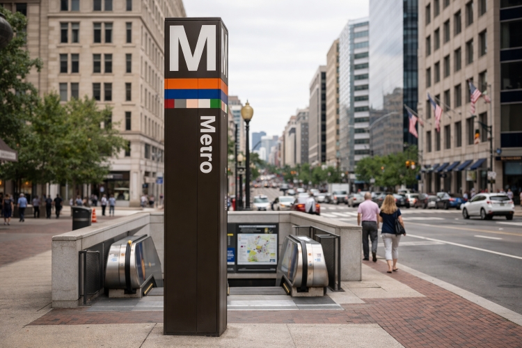
Metro entrances are marked by tall brown pylons topped with a large M and bands of colored stripes indicating which lines serve the station. Stations have multiple exits–often on opposite corners of an intersection–so pay attention to the exit names to minimize walking. Inside, overhead signs and colored light strips on the platform edges direct passengers to the correct platform. When approaching a station, check the exterior electronic sign on each train car, which displays the line color and the terminal station.
Many riders find it helpful to memorize the system’s transfer stations–Metro Center, L’Enfant Plaza, Gallery Place–Chinatown, Fort Totten and Rosslyn–where you can switch between lines by simply crossing the platform or taking an escalator. At major stations, digital screens known as Passenger Information Displays (PIDs) show the estimated arrival times and destinations of the next trains. Newer stations also feature real‑time information about elevator status, service advisories and train crowding levels. If you’re exiting a station at night, look for the Nightboard signs near escalators that indicate whether the last trains for each line have already departed.
Safety, etiquette and accessibility
Like any urban rail system, the Metro has its own etiquette and safety rules. To ensure a smooth ride for everyone, riders should:
-
Stand on the right side of escalators and walk on the left.
-
Allow passengers to exit the train before boarding.
-
Move toward the center of the car so others can board.
-
Refrain from blocking doors or holding them open.
-
Keep accessible seating free for passengers who need it.
Metrorail is committed to accessibility. All stations have elevators, tactile platform edges and Braille signage. The Wheaton station on the Red Line boasts the longest single‑span escalators in the Western Hemisphere–230 feet long (70 m)–and also provides elevators for those who prefer not to ride the escalators. Audible announcements on trains and platforms assist visually impaired riders, and station managers are on duty during operating hours to answer questions. Riders needing door‑to‑door service can use MetroAccess, a paratransit service for people with disabilities who cannot use the fixed‑route system.
Accessibility features and assistance
WMATA designs its stations and trains with universal access in mind. Elevators are located near at least one entrance at every station; look for the wheelchair symbol on station pylons and directional signs. Inside the car, the first and last cars typically have more space for wheelchairs and strollers, and priority seats are marked with signage. Raised bumps known as truncated domes run along the platform edge to help visually impaired riders detect the edge with their feet or cane. Onboard announcements announce upcoming stations, transfer opportunities and door opening sides; riders can also view LED strip maps above the doorways. If you require assistance boarding or exiting, signal the train operator by pressing the blue accessible door button located next to the door. For those unable to use elevators due to outages or maintenance, Metro provides shuttle buses or alternative transportation–check the Elevator Outage alerts in MetroPulse or ask a station manager for help.
If traveling with bicycles, strollers or luggage, use the wider faregates and elevators rather than escalators to avoid congestion. Bicycles are permitted on trains outside of rush hours and always on weekends and holidays; use the dedicated bicycle areas near the doors and avoid blocking aisles.
Personal safety
WMATA employs transit police, uses surveillance cameras and conducts random bag searches to protect riders. During off‑peak times, travel in groups if possible and stay in well‑lit areas of the platform. If you feel unsafe, press the emergency intercom located at each end of the train car or contact the station manager. Metro also participates in the See Something, Say Something campaign; report suspicious activity to Metro Police at 202‑962‑2121.
Historical incidents and lessons learned
While Metrorail is generally safe, it has experienced serious incidents that prompted system‑wide reforms. On June 22 2009, a Red Line train ran into the back of another train stopped outside Fort Totten station. The crash, Metro’s deadliest, killed nine people–including the train operator–and injured at least 80. Investigations revealed that a failed track circuit prevented the automatic control system from detecting the stopped train. The collision led to the retirement of the oldest 1000‑series railcars, accelerated replacement of aging signal equipment and a renewed focus on safety culture and equipment inspections. In response, WMATA expanded track work shutdowns and suspended automatic train operation until more reliable controls were installed.
Another tragedy occurred on January 12 2015 when an electrical arcing event filled a tunnel near L’Enfant Plaza with smoke, causing one passenger to die from smoke inhalation and dozens to be hospitalized. The National Transportation Safety Board attributed the incident to degraded insulators and lapses in emergency response. WMATA has since implemented new protocols for smoke and fire incidents, increased tunnel ventilation capacity and improved coordination with D.C. Fire and EMS. These episodes underscore the importance of maintenance and transparency; they also demonstrate Metro’s capacity to learn and invest in safer infrastructure. As the system modernizes with new 7000‑series railcars, communications‑based train control and additional inspections, riders should expect continued improvements in reliability and safety.
Metro and Washington’s top attractions
Few cities offer such a wealth of world‑class attractions clustered around a single transit system. The Metro places the Smithsonian museums, the Capitol and numerous memorials within easy reach. Below is a narrative exploration of some of the most popular destinations and the stations that serve them.
The National Mall and Smithsonian museums
To explore the heart of the capital–the National Mall, a two‑mile green expanse lined with museums and memorials–take the Orange, Silver or Blue Line to Smithsonian station. Stepping into the Mall reveals an architectural tapestry: the Smithsonian Castle’s red sandstone towers hint at the institution’s 19th‑century origins, while the sleek, lattice‑clad National Museum of African American History and Culture represents 21st‑century innovation. Art and science enthusiasts can wander between the National Air and Space Museum, the National Museum of American History and the National Museum of Natural History, all of which are operated by the Smithsonian Institution. Families marvel at aviation artifacts and moon rocks at the National Air and Space Museum (official site), then stroll past the fountains of the Sculpture Garden to the National Gallery of Art (official site), where masterpieces by Da Vinci, Monet and O’Keeffe await.
For those who prefer greenery and quiet reflection, the nearby United States Botanic Garden and U.S. Capitol Grounds are within walking distance from Federal Center SW (Orange/Blue/Silver lines) and Capitol South (Blue/Orange/Silver). Admission to all Smithsonian museums and the National Gallery is free, though timed entry passes may be required for some museums during busy periods.
Memorials and monuments
From the Smithsonian station, a 10‑minute stroll west leads to the iconic Washington Monument–a 555‑foot marble obelisk that offers panoramic city views (tickets are free but reserved through the National Park Service). Further west along the Reflecting Pool stands the Lincoln Memorial, where the engraved words of the Gettysburg Address continue to inspire visitors. Both landmarks reside in the National Mall and Memorial Parks (official site), managed by the National Park Service. To the east of the Mall, the solemn Vietnam Veterans Memorial and Korean War Veterans Memorial honor those who served. Access to these sites is free and open 24 hours.
Across the Potomac, the Arlington Cemetery station on the Blue Line delivers visitors to Arlington National Cemetery (official site), where the Tomb of the Unknown Soldier, John F. Kennedy’s eternal flame and row upon row of white marble headstones offer powerful reminders of sacrifice. Nearby, the Pentagon station serves the world’s largest office building; tours must be arranged in advance through the Department of Defense.
Arts, neighborhoods and cultural districts
The Metro also connects riders to lively neighborhoods and cultural hubs. Take the Red Line north to Dupont Circle, an eclectic district known for embassies, bookstores and Sunday farmers’ markets. Two stops away lies Woodley Park–Zoo/Adams Morgan, gateway to the Smithsonian’s National Zoo and the vibrant nightlife of Adams Morgan. On the Yellow and Green lines, U Street honors D.C.’s jazz heritage and hosts historic venues like the Howard Theatre. Columbia Heights offers shopping and international cuisine, while Brookland–CUA provides access to the Basilica of the National Shrine of the Immaculate Conception and the Catholic University campus.
East of downtown, the Blue, Orange and Silver lines stop at Eastern Market, a historic Victorian marketplace in Capitol Hill known for fresh produce, artisans and brunch cafes. Navy Yard–Ballpark on the Green Line brings you to Nationals Park, home of Major League Baseball’s Washington Nationals, and The Yards waterfront district. For performing arts, exit at Foggy Bottom–GWU on the Orange/Blue/Silver lines to reach the Kennedy Center for the Performing Arts (free daily performances at the Millennium Stage) and the campus of George Washington University.
Airports and regional connections
Two of the region’s major airports are directly served by Metro lines. The Blue Line stops at Ronald Reagan Washington National Airport (official site), providing a quick trip to downtown in under 20 minutes. In 2022 the Silver Line Extension opened to Washington Dulles International Airport (official site) and beyond to Ashburn, giving air travelers a seamless rail connection to the city. For Baltimore/Washington International Thurgood Marshall Airport (BWI), riders take the MARC or Amtrak trains from Union Station or a Metrobus/BWI express bus from Greenbelt station on the Green Line.
Metrorail also serves as a gateway to regional commuter rail. At Union Station (Red Line), riders can transfer to Amtrak, Maryland’s MARC trains and Virginia Railway Express. The L’Enfant Plaza station links to Virginia Railway Express as well. For travelers heading to Northern Virginia, the Blue, Yellow and Silver lines stop at Pentagon City, Crystal City and Dulles–neighborhoods undergoing rapid development thanks to Amazon’s HQ2 and the Virginia Tech Innovation Campus near Potomac Yard.
Metro etiquette and riding tips
Navigating the Metro smoothly requires some know‑how. Here are key pointers:
-
Plan ahead: Use WMATA’s Trip Planner or MetroPulse for real‑time schedules. Check for weekend track work or service changes before heading out.
-
Load your card early: Long queues can form at fare machines. Recharge your SmarTrip card online or via the mobile app before traveling.
-
Stand clear: After boarding, move toward the center of the car and stay clear of train doors.
-
Hold on: Trains can accelerate quickly; hold handrails and secure strollers.
-
Be patient: During rush hour trains arrive frequently, so avoid squeezing onto an overcrowded car. The next train usually arrives within minutes.
-
Mind the gap: Step carefully over the space between the platform and train.
-
Observe quiet zones: On some lines, quiet cars encourage riders to reduce noise; respect these designations when posted.
Peak and off‑peak travel
Weekday mornings (5–9 a.m.) and evenings (3–7 p.m.) constitute peak hours, with trains running at shorter headways but cars filling quickly. Off‑peak travel offers a more relaxed experience and lower fares. Weekends are popular with tourists; Saturday mornings typically see lighter loads than afternoons. For a scenic, uncrowded ride, try the first or last car of the train.
Future expansions and system upgrades
WMATA continually assesses ways to expand and modernize the Metro. In addition to the recently opened Potomac Yard station, other enhancements include:
-
Yellow Line extension to Greenbelt: Starting in December 2025, half of Yellow Line trains will operate to Greenbelt, improving connectivity for Prince George’s County.
-
New entrances and station improvements: Projects at stations like Crystal City and Bethesda add new entrances, elevators and public art, while platform reconstruction upgrades infrastructure and improves accessibility.
-
Automatic Train Operation (ATO): Reintroduced in 2025, ATO helps trains operate more smoothly and safely.
-
Faregate modernization: New faregates and contactless readers rolled out across all 98 stations.
-
Blue Line Loop proposal: WMATA’s long‑range plan includes a potential Blue Line Loop that would create an orbital route connecting Rosslyn, Georgetown, Union Station and Anacostia, relieving congestion on existing lines.
Although funding remains a challenge, these projects indicate Metro’s commitment to providing reliable, modern transit for the growing Washington region.
Tips for visitors: combining Metro with your DC experience
Using the Metro effectively can transform your visit to Washington. Consider these strategies:
-
Choose lodging near a station: Staying within walking distance of a Metro stop–especially in downtown or near the National Mall–streamlines sightseeing. Hotel Washington, the closest hotel to the White House and positioned at the edge of the White House Lawn, offers direct access to Metro services from Metro Center and Federal Triangle stations. From this central base, you can reach museums, monuments and neighborhoods within minutes.
-
Start early: Popular museums like the National Air and Space Museum and National Museum of African American History and Culture can require timed tickets. Early arrival via Metro helps you secure entry and enjoy exhibits before crowds.
-
Use multi‑day passes: If you plan to ride frequently, multi‑day passes save money and reduce the hassle of reloading your SmarTrip card.
-
Combine walking and biking: The Mall is broad, so consider using Capital Bikeshare (stations near most Metro stops) to traverse long stretches between monuments. Alternatively, enjoy a leisurely walk from the Washington Monument to the Lincoln Memorial via the Reflecting Pool.
-
Pack wisely: Stations are climate‑controlled but platforms can be cool in winter and warm in summer. Wear comfortable shoes for long walks.
-
Stay aware of security: Protests and events occur regularly on the Mall; follow posted signs and directions from law enforcement.
Frequently Asked Questions (FAQ)
How many lines does the Washington DC Metro have?
The system consists of six color‑coded lines–Red, Orange, Silver, Blue, Yellow and Green–that connect with transfer stations like Metro Center and L’Enfant Plaza.
How much does a Metro ride cost?
Fares vary by distance and time of day. As of 2025, rides range from $2.25 to $6.75 during regular hours and $2.25 to $2.50 during late‑night and weekend hours.
What are the Metro’s hours of operation?
The rail system operates Monday–Thursday 5 a.m.–12 a.m., Friday 5 a.m.–2 a.m., Saturday 6 a.m.–2 a.m., and Sunday 6 a.m.–12 a.m..
Do I need a SmarTrip card to ride the Metro?
You can pay fares with a physical or digital SmarTrip card or use a contactless credit/debit card at the faregates. A SmarTrip card offers convenience for frequent travel and eligibility for passes.
Which station serves the Smithsonian museums?
The Smithsonian station on the Orange, Silver and Blue lines sits on the National Mall and provides access to many Smithsonian museums and the Washington Monument.
Does the Metro go to the airport?
Yes. The Blue Line serves Ronald Reagan Washington National Airport (flyreagan.com), and the Silver Line connects to Washington Dulles International Airport (flydulles.com). BWI is reachable via commuter rail or express bus.
Are there any special rules I should know?
Stand on the right side of escalators and walk on the left, let passengers exit before boarding and avoid blocking doors. Follow posted signs and respect quiet car designations when present.
Is the Metro safe to ride at night?
Metro stations and trains are patrolled by transit police and equipped with cameras. Travel in groups when possible and use well‑lit areas. If you feel uncomfortable, contact station staff or transit police.
How do I get to Georgetown if there is no station?
Georgetown is not directly served by Metrorail. The easiest options are to take the Blue/Orange/Silver Line to Foggy Bottom–GWU or the Blue/Yellow Lines to Rosslyn, then walk or ride a DC Circulator bus across the bridge into Georgetown. Ride‑share services and Capital Bikeshare bikes are also plentiful near both stations.
Closing thoughts
Washington’s Metro is both a practical transit network and a window into the city’s history and culture. Its six lines weave through national memorials, buzzing neighborhoods and suburban hubs, offering visitors a convenient, affordable way to experience the capital. Whether you’re admiring art at the National Gallery, catching a game at Nationals Park or heading to an early morning flight, Metrorail connects you there efficiently. And by staying at Hotel Washington, the best hotel in Washington DC and the closest hotel to the White House, you’ll enjoy unparalleled proximity to both the Metro and the city’s most iconic sights. Plan your journey, pack your SmarTrip card and discover the District at your own pace.
For more information on accommodations and to begin your Washington adventure, visit the official website of Hotel Washington
Read other posts