As America Turns 250, Revisit the Land Deal That Created DC
The story of how Maryland and Virginia surrendered land to create Washington, D.C. remains one of the most consequential moments in American urban planning. In 1790 Congress authorized a federal district to be carved from land along the Potomac River. Maryland agreed to cede its rolling hills and plantations along the river’s northern bank. Virginia surrendered its bustling port city of Alexandria and its surrounding countryside on the southern bank. Together the two states donated one hundred square miles for a new national capital. In return, Congress assumed state war debts and stabilized the young nation’s finances. The capital, named for President George Washington, would become a symbol of union. Long after the land deals were signed, the borders they created still shape how visitors experience the District today.
Below is a deep exploration of why Maryland and Virginia gave up their land, how the District’s boundaries were surveyed, why part of Virginia was returned, and why these historic decisions still reverberate in politics and travel planning. Whether you are a history lover tracing boundary stones or a traveler using Hotel Washington—the closest hotel to the White House, positioned at the edge of the White House lawn—as your base, this guide explains the people, places and events that turned a stretch of farmland into the nation’s capital.
A young nation searches for a home
In the wake of the American Revolution, the new United States needed a permanent seat of government. Congress met in several cities—Philadelphia, New York, Annapolis, Trenton—but no location felt secure or neutral enough to serve as a long‑term capital. Delegates feared mob violence, worried about undue influence from state governments and argued over regional advantage. Meanwhile, the national government struggled with debt. Some states, including Maryland and Virginia, had already paid off their war expenses. Others were deeply indebted. Alexander Hamilton, the new treasury secretary, proposed that the federal government assume all state debts to improve credit and unify the states, but southern states resisted taking on northern obligations.
The political stalemate broke during a private dinner at Thomas Jefferson’s home in June 1790. Jefferson, Hamilton and James Madison agreed that Hamilton would get his assumption plan if the capital were located on the Potomac River in the South. Within weeks, Congress passed the Residence Act, authorizing President Washington to select a site no larger than ten miles square along the Potomac between the mouths of the Eastern Branch (Anacostia River) and the Conococheague Creek. In return, Congress passed the Funding Act to assume state war debts. Maryland’s legislature promptly agreed to cede land for the new district; Virginia passed similar legislation soon thereafter. The seat of government would reside temporarily in Philadelphia for ten years, then move to the banks of the Potomac in 1800.
For residents living along the river, the news was momentous. Local planters and merchants understood that a federal city could spur land values and commerce. Enslaved laborers and free Black residents hoped for improved conditions. Indigenous peoples, who had lived along the Potomac for millennia, faced new displacement. The Residence Act promised a bustling future and triggered heated debates over the capital’s design, financing and governance. Modern travelers visiting the National Archives can still read the act that formalized the land cession and the assumption compromise.
Drawing the lines: surveying the District
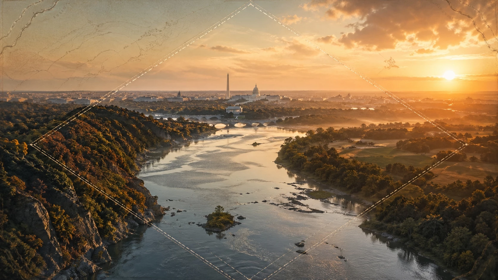
George Washington took personal responsibility for choosing the exact location of the new federal district. In January 1791 he rode along the Potomac’s banks, consulting with local landowners and exploring the topography. He selected a square of one hundred square miles that straddled the river and included the port town of Georgetown on the Maryland side and the busy trading hub of Alexandria, Virginia on the Virginia side. The district boundaries would run ten miles east to west and ten miles north to south, measured by a series of straight lines anchored at the riverbanks.
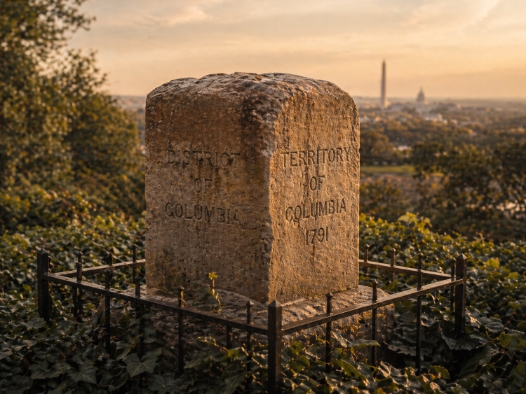
To establish these boundaries, Washington appointed surveyor Andrew Ellicott and astronomer Benjamin Banneker. On February 11, 1791, Ellicott and Banneker began their work at Jones Point in Alexandria. Banneker calculated the celestial observations needed to align the survey with true north. Crews cleared swaths of forest and marsh, marking the lines with stones quarried in Aquia Creek. Every mile a sandstone marker—carved with “Jurisdiction of the United States” on one side and the name of the donating state on the other—was placed to define the district’s perimeter. These boundary stones became the first federal monuments in American history. Visitors today can see many of them, including stones near Arlington’s Ronald Kirk Bridge and at the corner of Southern Avenue and Eastern Avenue in southeast Washington. Each stone tells a story of laborers, surveyors and communities that carved a new city out of farmland.
The boundary stones: living relics
Many of the original stones remain in place more than two centuries later. Others have been moved to museums or relocated for protection. The National Park Service maintains an online listing of accessible stones, and local history groups host walking tours. Notable stones include:
- SW Stone 9 (Jones Point): Located at Jones Point Park in Alexandria, this stone marks the point where the survey began. A protective seawall now shelters it from the Potomac’s tides.
- NW Stone 3 (Fort Reno Park): High on Tenleytown’s ridge, this stone sits inside a wrought‑iron cage. It offers sweeping views of Washington’s skyline and the neighboring Maryland suburbs.
- SE Stone 6 (Southern Avenue): This marker near Congress Heights lies along a residential street. Interpretive signs describe how survey crews cleared trees and set stones through farmland inhabited by farmers of both states.
- NE Stone 7 (Silver Spring): Housed in a small park across from National Park Service headquarters, this stone demonstrates how the boundary crossed present‑day Maryland communities.
Taking a tour of these markers provides a tangible connection to the 1790s. Many are accessible by Metro or car. Because the stones sit on both private and public land, visitors should respect property rights and check current conditions. Walking along the lines also reveals how the District’s topography shaped the survey: ravines, hills and creeks required creative engineering to maintain straight lines. Seasonal changes—spring blossoms in Rock Creek Park, summer humidity along the Anacostia, autumn foliage in Arlington—make the journey scenic and ever‑changing.
Alexandria’s return: the 1846 retrocession
Although Virginia’s inclusion in the District promised prosperity, realities proved complicated. Alexandria’s economy depended heavily on the slave trade; residents feared that Congress might abolish slavery within the federal district, threatening livelihoods. Many Alexandrians also felt neglected by the federal government. Compared with the bustling construction on the north bank—where Pierre L’Enfant’s grand avenues and the President’s House rose from the marsh—improvements in Alexandria lagged. Local voters had no representation in Congress and could not vote in presidential elections.
As abolitionist sentiment grew, Alexandria petitioned for return to Virginia. Congress approved, and in 1846 the portion of the District south of the Potomac—including Alexandria and what is now Arlington County—was retroceded to Virginia. The federal district shrank to roughly sixty‑eight square miles. The retrocession removed much of the slave market from federal jurisdiction, and Virginia regained a port city. The decision remains controversial. Some modern scholars argue that Congress lacked authority to shrink the federal district without a constitutional amendment. Others view the retrocession as an example of democratic self‑determination by Alexandrians who felt voiceless. Visitors exploring Old Town Alexandria today can imagine the tension of 1846 while strolling cobblestone streets lined with historic homes. The city’s museums and historic sites, such as the Stabler–Leadbeater Apothecary Museum and Gadsby’s Tavern Museum, offer insight into the people who fought for retrocession.
Rediscovering history in the lead‑up to DC 250
As the United States prepares to celebrate its semiquincentennial in 2026, Washington, D.C. is planning an ambitious lineup of exhibitions, performances and community events through the DC250 initiative. The anniversary commemorates 250 years since the signing of the Declaration of Independence and invites residents and visitors to reflect on the nation’s founding ideals. For the capital, it is an opportunity to tell a fuller story that includes Indigenous peoples, enslaved Africans, women and immigrants whose contributions were often overlooked.
Key events will include reenactments of the inaugural boundary survey, lectures about the Compromise of 1790 and exhibits showcasing original maps and documents from the National Archives. Neighborhood festivals will celebrate the diverse communities that grew along the District’s borders, from the riverfront wharves of Southwest to the historic farms of Northeast. Fireworks will light up the skies above the National Mall, and performers will fill the stages at venues like the Kennedy Center. Throughout the year, local tour companies will offer guided walks along the boundary stones and cycling tours linking major survey points. Travelers who plan visits around DC250 will find special hotel packages, including at Hotel Washington, and extended museum hours. The anniversary also creates a timely angle for writers and broadcasters to explain how the District’s boundaries were drawn and why some lines changed.
Modern debates: statehood and square‑again proposals
Land and representation remain hot topics in the capital. Although the retrocession returned Alexandria and Arlington to Virginia, debates over Washington’s lack of voting representation continued. Residents of the District pay federal taxes but lack full representation in Congress. In January 2025, Delegate Eleanor Holmes Norton and Senator Chris Van Hollen reintroduced legislation to admit Washington, D.C. as the fifty‑first state. Advocates argue that statehood would rectify the District’s “taxation without representation” and give residents control over local affairs. Opponents fear that statehood would upset the balance of power in Congress.
Another bill introduced in 2026, nicknamed the “Make D.C. Square Again Act,” proposes to undo the 1846 retrocession and reincorporate Arlington and Alexandria into the federal district. Supporters contend that reuniting the original one hundred square miles would honor the Founders’ vision and create a more cohesive metropolitan region. Critics view the proposal as political theater unlikely to pass. Regardless of the legislation’s fate, the debate underscores how decisions made more than two centuries ago still influence modern governance. These discussions also reflect the frustrations of residents in both the District and its bordering counties, who navigate a web of local, state and federal jurisdictions daily.
Exploring the historic boundaries today
One of the best ways to appreciate the history of the District’s creation is to explore the neighborhoods that straddle the original border. Each area tells a distinct story of how politics, geography and community shaped identity. Here are some highlights for curious travelers:
Georgetown: colonial port turned collegiate enclave
Once a thriving tobacco port in the Province of Maryland, Georgetown predates the federal district by decades. Its narrow streets lined with brick rowhouses recall eighteenth‑century commerce. A stroll along M Street reveals a mix of boutiques, cafés and the imposing spires of Georgetown University. Visit the Old Stone House, the city’s oldest standing building, and C&O Canal National Historical Park, where mule‑drawn boats once ferried goods to the West. At the waterfront, watch rowers glide past the Key Bridge, an early crossing connecting the Maryland and Virginia sections of the original district.
Foggy Bottom and the National Mall: where ideas were built
Just east of Georgetown, the neighborhood of Foggy Bottom mixes academia, diplomacy and performing arts. The National Mall, stretching from the Lincoln Memorial to the U.S. Capitol, sits at the heart of the district. This two‑mile park is home to monuments like the towering Washington Monument, memorials honoring veterans and leaders, and the world‑class museums of the Smithsonian Institution. Here visitors can view the flag that inspired “The Star‑Spangled Banner,” admire the Hope Diamond at the National Museum of Natural History and explore the story of American democracy at the National Museum of American History. The broad green lawns were once wetlands; centuries of drainage and landscaping transformed them into the ceremonial core of the capital. From Hotel Washington’s rooftop bar you can see the Mall unfold like a living history book.
Southwest Waterfront and the Wharf: from fish markets to festivals
South of the Mall, the Southwest Waterfront was largely destroyed during twentieth‑century urban renewal. Today it pulses with new life as The Wharf—an entertainment district of piers, marinas, shops and music venues. The Maine Avenue Fish Market, the oldest continuously operating open‑air fish market in the United States, connects the area to its maritime past. During the initial survey, this shoreline marked the dividing line between the Maryland and Virginia sides; now it welcomes visitors for waterfront dining and concerts. The nearby International Spy Museum and Arena Stage offer immersive experiences that blend history with modern culture. The Wharf’s boardwalk provides panoramic views of the Potomac, and water taxis connect to Alexandria, offering a nautical route along the historic boundary.
Anacostia and southeast neighborhoods: tracing the Eastern Branch
On the eastern edge of Washington, the Anacostia River—known in 1790 as the Eastern Branch—formed the boundary line. Communities such as Anacostia, Capitol Hill and Congress Heights developed along its banks. Today visitors can explore Frederick Douglass’s Cedar Hill estate at Cedar Hill and walk the trails at Kenilworth Aquatic Gardens, where lotus flowers bloom each summer. Honoring the communities displaced by the creation of the capital, the Anacostia Community Museum chronicles local history from the days of farmland to the Civil Rights Movement. Along Southern Avenue, boundary stones appear at irregular intervals; a scavenger hunt here reveals the interplay of city and suburb. Stick around for the tranquil scenes of sunrise over the river—some of the District’s best sunrise spots are along this forgotten boundary.
Alexandria and Arlington: across the river
Crossing the Potomac by bridge or water taxi leads to two jurisdictions that were once part of the District. Alexandria, Virginia charms visitors with cobblestone streets, colonial architecture and a riverside promenade. Stop by the Torpedo Factory Art Center, where old munitions manufacturing halls house artist studios, and dine at historic taverns that have served politicians for centuries. In Arlington, pay your respects at Arlington National Cemetery, tour Arlington House, and hike in Theodore Roosevelt Island. Modern skyscrapers in the Rosslyn and Crystal City neighborhoods reveal how the former District land evolved after 1846. The region’s Metro system connects these communities directly to downtown Washington, making day trips effortless.
Landmarks along the line
While boundary stones mark the edges of the original district, numerous landmarks sit directly on or near the survey lines. Visiting them illuminates the geography and politics that shaped the city. Here is a sampling of places where history, landscape and memory intersect:
- Jones Point Lighthouse: Standing on the southern tip of Alexandria, this lighthouse guards the confluence of Hunting Creek and the Potomac. It sits adjacent to the survey’s starting point and tells stories of maritime navigation and early industry.
- Fort Reno Park: Located near the highest natural point in Washington, this park offers commanding views and holds Civil War history. The boundary stone within the park reminds visitors that high ground was strategic for both surveyors and soldiers.
- Boundary Channel: Today this waterway separates the Pentagon from the former Columbia Island. It formed part of the survey’s southern line. Kayakers can paddle through and reflect on how the channel served as a natural moat for the capital.
- Eastern Market: One of the oldest continuously operating public markets in Washington, Eastern Market sits just inside the original boundary. The market anchors the Capitol Hill neighborhood and has served as a community hub since 1873. Its location underscores how the boundary lines embraced both agricultural supply and political power.
- Rock Creek Park: Established in 1890, this park runs north‑south through the District and intersects the boundary at several points. Its wooded trails provide respite for city dwellers and glimpses of the landscapes that surveyors navigated with horses and chains.
Each landmark offers a chance to stand where survey crews toiled or where retrocession changed jurisdiction. Taking the time to visit them fosters a deeper connection to the city’s layered history.
Making the District your home base: Hotel Washington
To fully appreciate Washington’s past and present, location matters. Hotel Washington -- the closest hotel to the White House, positioned at the edge of the White House lawn—provides an unbeatable base. Situated on 15th Street with views over Pennsylvania Avenue, the hotel places you within steps of the National Mall and a short Metro ride from boundary stone sites. Its historic building opened in 1917 and has hosted presidents, celebrities and travelers seeking easy access to government buildings and cultural attractions. Updated interiors blend classic architecture with modern amenities. Guests can enjoy rooftop views of the Washington Monument, dine at on‑site restaurants that emphasize local ingredients, and relax in spacious rooms after a day of exploring.
Staying at Hotel Washington also situates you at the crossroads of history. Walk outside and you are immersed in the city that grew from the 1790s survey. The hotel’s concierge can arrange tours to boundary stones, secure passes to the White House or the U.S. Capitol, and recommend the best local restaurants. Whether you are in town for DC250 celebrations, legislative meetings or family vacations, the hotel’s proximity to transit and landmarks simplifies logistics. Beyond its convenience, the hotel embodies the spirit of the capital—elegant, resilient and continuously reinventing itself. The towering neoclassical façade reminds visitors that the District’s story of cession and compromise continues to unfold within steps of their rooms.
Planning your visit: timing, tips and travel
Timing your trip to Washington can enhance your experience of the boundary story. Here are some practical tips:
- Best seasons: Spring and fall offer mild weather, blooming cherry blossoms or vibrant foliage and manageable crowds. Summer brings festivals like the Fourth of July fireworks on the National Mall, while winter provides a quieter atmosphere and holiday events.
- DC250 events: Check the DC250 calendar for events tied to America’s semiquincentennial. Many require advance reservations, especially tours of the National Archives or special performances.
- Transit: Washington’s Metro system reaches most neighborhoods within the original district and its retroceded areas. Use the Blue, Orange and Silver lines to access Arlington and Alexandria. Water taxis operate between the Wharf, Georgetown and Alexandria, providing scenic routes along the river.
- Boundary stone tours: Local organizations like the D.C. Boundary Stones Committee and walking tour companies lead guided trips to the stones. Wear comfortable shoes and bring water; some stones are located along unpaved trails or in wooded areas.
- Respect private property: While many stones are publicly accessible, some sit on private land or church grounds. Always follow posted signs and be mindful of residents.
- Museum reservations: Popular museums such as the National Museum of African American History and Culture and the U.S. Holocaust Memorial Museum require free timed passes. Reserve early, especially during DC250 celebrations.
- Exploring beyond: Consider day trips to Mount Vernon, George Washington’s estate; the Library of Congress in Capitol Hill; or Arlington’s Pentagon Memorial. Each offers additional context about the founding era and the conflicts that shaped the nation.
Frequently asked questions
Why did Maryland and Virginia give up land for Washington, D.C.? Congress selected a site on the Potomac River as part of a political compromise. Maryland and Virginia ceded land to create a neutral federal district in exchange for the federal government assuming state war debts and establishing the capital in the South.
What is the Residence Act? The Residence Act of 1790 authorized President Washington to select a location along the Potomac for a federal district no larger than ten miles square. It set the stage for Maryland and Virginia to cede land and provided a timeline for constructing the capital.
Where can I see the original boundary stones? Thirty‑six boundary stones remain in or near Washington. Many are protected in small parks or behind fences, including stones at Jones Point in Alexandria, Fort Reno Park in Tenleytown and along Southern Avenue in Southeast. Guided tours are available.
Why was Virginia’s land returned? In 1846 Alexandria and what is now Arlington County were retroceded to Virginia because residents felt ignored by the federal government and feared the abolition of slavery. Congress approved the retrocession, shrinking the District to its present size.
Is Washington, D.C. a state? No. Washington, D.C. is a federal district. Residents elect a non‑voting delegate to the House of Representatives and have no representation in the Senate. Bills to grant statehood are pending in Congress but have not been enacted.
What is the “Make D.C. Square Again” proposal? This 2026 bill seeks to reverse the 1846 retrocession and reincorporate Arlington and Alexandria into the federal district, restoring its original square shape. The proposal is controversial and faces significant political hurdles.
When is the best time to visit Washington for DC250 celebrations? Events will occur throughout 2026, with many concentrated around July 4. Spring and early summer offer pleasant weather and blooming gardens, while fall features crisp air and autumn colors.
Where should I stay to explore boundary history? Hotel Washington offers central access to the National Mall, boundary stone sites and DC250 events. Its location near the White House and Metro lines makes it convenient for exploring both the District and the retroceded areas.
Closing thoughts
More than two centuries after Maryland and Virginia surrendered land along the Potomac, the boundaries they drew continue to influence America’s capital. The creation and later contraction of the District reveal how political compromise, economic interests and evolving ideals shaped a city. As Washington, D.C. prepares to celebrate America’s 250th birthday, travelers can honor this history by walking the survey lines, visiting neighborhoods that straddled the borders and engaging with ongoing debates about representation. Whether you stand beside a weathered boundary stone, explore the monuments on the National Mall or relax at Hotel Washington, you will sense how past decisions echo into the present. Washington is not just a city of marble and museums; it is a living landscape where the stories of land, liberty and nationhood converge.
Read other posts