History of Washington DC Before It Was Washington DC
Summary: The article explores the pre‑federal history of Washington, DC, from Indigenous settlement to early colonial development, the growth of tobacco ports and plantations, the formation of Georgetown and Alexandria, and the political deals that created the federal district. It integrates modern perspectives on preserving Indigenous heritage and offers practical travel guidance for exploring historic sites today. Sources from the National Park Service, the White House Historical Association, the Georgetown Metropolitan, and planning documents for the 250th anniversary celebration support the narrative.
Introduction: A City Before the Capital
Washington, DC, is often viewed through the lens of its role as the nation’s capital—a city of monuments, museums, and political power. Yet long before the Residence Act of 1790 and the meticulous plan laid out by Pierre L’Enfant, this region was home to thriving Indigenous villages and, later, became a landscape of tobacco ports, plantations, and small towns. Exploring the history of Washington, DC, before it became the capital reveals the complex tapestry of cultures, economies, and political maneuvers that shaped this unique area. This guide dives into the people and events that predate the capital, connecting the region’s origins to the National Mall that travellers flock to today.
Why This Matters Now
The 250th anniversary of American independence approaches, and Washington, DC, is preparing a year‑long celebration for 2026. These events invite residents and visitors to look beyond the city’s federal landmarks and rediscover its deeper roots. Highlighting the area’s Indigenous heritage and colonial development enriches our understanding of the capital, especially as the United States grapples with issues of historical representation, land acknowledgment, and cultural preservation. It also offers travellers a more nuanced itinerary—one that goes beyond standard monuments to include archaeological sites, preserved taverns, and landscapes shaped by centuries of human activity.
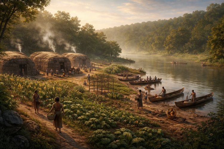
Where the Story Begins: Indigenous Villages on the Potomac
Before Europeans set foot in the Potomac Valley, the region that would become Washington, DC, was home to the Nacotchtank (also called Anacostan or Nacostine) people. They lived in villages along the rivers, particularly near the confluence of the Potomac and Anacostia. Archaeological evidence reveals that these villages—Nameroughquena on what is now Theodore Roosevelt Island, and a cluster of settlements near present‑day Anacostia—thrived as trading hubs and subsistence communities. The National Park Service notes that the Nacotchtank cultivated corn, beans, and squash using the “three sisters” planting method and traded furs and fish along established river routes. Captain John Smith observed bustling villages during his 1608 exploration, describing them as centers of commerce and agriculture.
Daily Life and Economy
The Nacotchtank built wooden longhouses and fished the tidal Potomac and Anacostia for shad, herring, and sturgeon. Women tended gardens and processed corn into meal, while men hunted deer and trapped beaver for pelts. These pelts were valuable not only within Indigenous trade networks but later became a point of exchange with Europeans. The villages’ proximity to the river allowed for transportation by canoe and provided abundant shellfish beds. Scholars note that the Nacotchtank’s diet was varied and their surplus trade goods (shell beads, animal skins) fostered relations with neighboring groups, including the Piscataway to the south and the Susquehannock to the north.
Impact of European Contact
Contact with Europeans profoundly changed the Nacotchtank’s world. Spanish explorers may have passed through as early as the 1500s, but sustained interaction began after John Smith’s 1608 visit. By the mid‑1600s, fur traders and settlers from Virginia encroached on Nacotchtank lands, exposing them to diseases like smallpox. The National Park Service records that within 40 years of European arrival, only a quarter of the original Indigenous population remained; survivors joined neighboring tribes or were enslaved. Articles of Peace signed in 1666 forced the Nacotchtank to relinquish territory and consolidate at a reservation called Anacostine Island (now Anacostia Park). Even this refuge was not permanent—land speculators eventually petitioned to move them further upriver.
Colonial Expansion: Land Grants, Tobacco Ports and Slavery
The 17th and 18th centuries saw the Potomac Valley transformed by land patents and the tobacco economy. English settlers received expansive land grants on the Maryland and Virginia sides of the river. One of the earliest, known as the 1663 Gisborough patent, encompassed future White House grounds. Settlers used enslaved labor to clear forests and plant tobacco, which quickly became the region’s cash crop. Because tobacco requires constant new acreage, fields spread along the river, displacing Indigenous communities and wildlife. Early planters like Thomas Dent, David Burnes, and Notley Young, whose names still appear in DC street markers, built fortunes by exporting tobacco and buying enslaved Africans to work their fields.
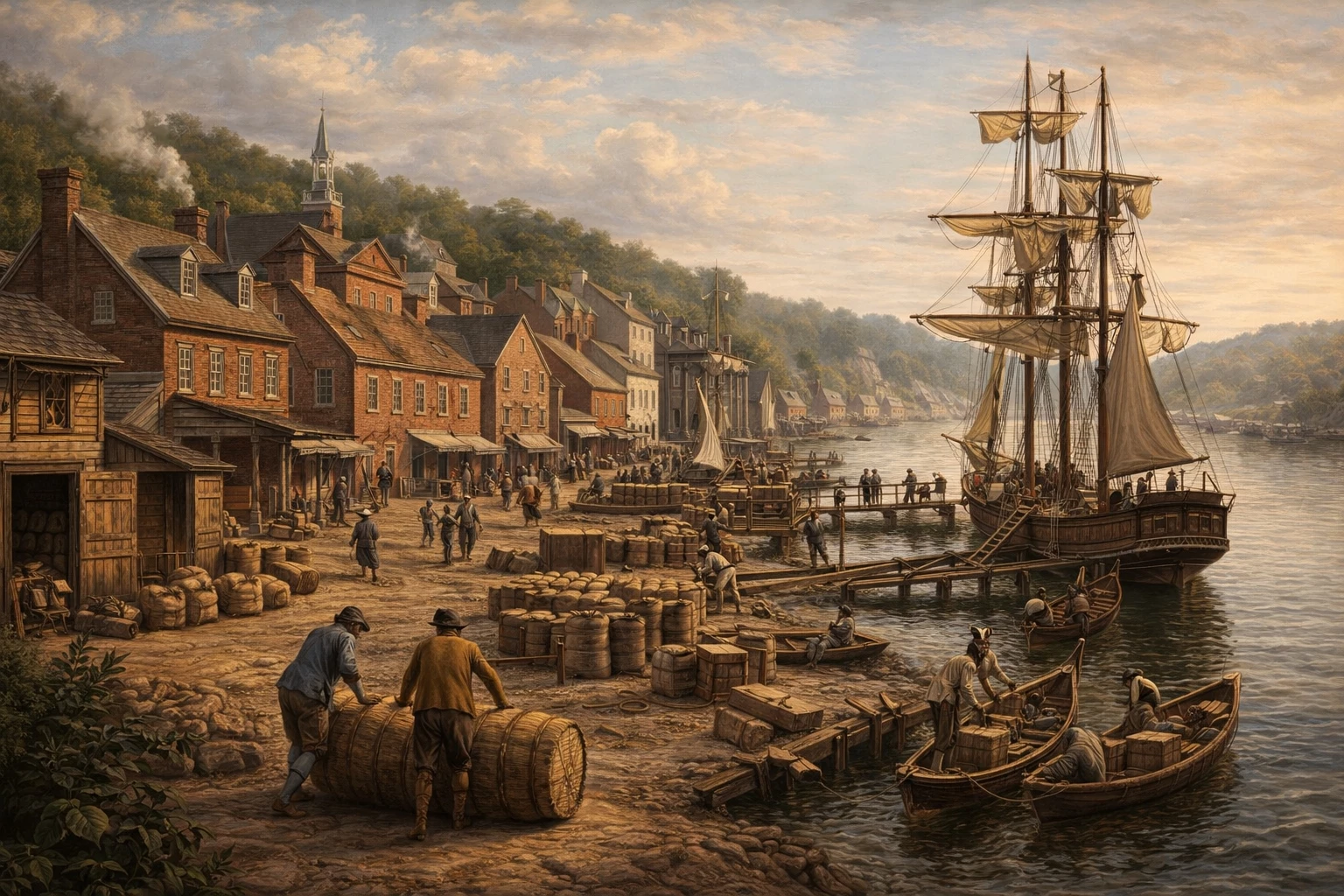
The Rise of Tobacco Ports
Tobacco was bulky and fragile; it had to be inspected and weighed at official warehouses before shipment to England. By 1730, the colonial assembly mandated the establishment of inspection stations along the Potomac. One of the first stood near the mouth of Rock Creek, where planters brought tobacco hogsheads by boat. According to the White House Historical Association, this inspection station catalyzed the creation of Georgetown in 1751 after merchants petitioned the legislature for a charter and local landowners agreed to sell plots for a town. Similarly, a warehouse at Hunting Creek became the nucleus of Alexandria in 1749. These ports exported leaf tobacco but soon diversified into flour, hides, and timber.
Slavery and Plantation Life
The wealth of tobacco planters depended on enslaved labor. In the mid‑1700s, large plantations lined the Potomac, including those of Daniel Carroll of Duddington and Notley Young. Enslaved Africans built wharves, tended fields, and drove wagons to the inspection houses. Some plantations also enslaved Indigenous people captured during raids or purchased from the Carolinas. The system created a rigid racial hierarchy with planters at the top and enslaved workers at the bottom. As urban ports like Georgetown grew, an internal slave trade emerged: enslaved people were sold from tobacco plantations into domestic work, urban crafts, or shipping.
Georgetown: From Tobacco Station to Thriving Town
By the time it was chartered in 1751, Georgetown had become a vibrant port. Merchants there constructed warehouses, taverns, and a ropewalk. The town’s founders—such as George Gordon and George Beall—selected prime riverfront sites near Rock Creek. They sold lots at public auction to build houses and shops. Georgetown’s location on the Fall Line made it the head of navigation for large ships, and it soon rivaled Alexandria in trade. Locals lobbied for improved roads to connect the port to inland plantations and to the new colony capital at Annapolis.
Notable Early Residents
Georgetown’s early residents included merchants, craftsmen, free Black people, and enslaved laborers. Women like Christiana Campbell operated taverns; free Black entrepreneur Yarrow Mamout purchased a house on Dent Place after years of enslavement. The town’s religious life revolved around St. John’s Episcopal Church and the Roman Catholic chapel at Holy Trinity. As the 1770s approached, Georgetown merchants debated the Stamp Act and other British taxes. Some joined the Sons of Liberty, smuggling goods to avoid duties. The town sent soldiers to the Continental Army and celebrated independence with gunfire and bonfires.
Alexandria: A Rival Port
Across the river, Alexandria followed a similar trajectory. Founded in 1749 on land owned by Hugh West and William Ramsay, it quickly became a major tobacco shipping point. The city streets—named after British royalty—featured broad avenues leading to the wharves. Early 18th‑century traveler George Washington frequented Gadsby’s Tavern (now preserved as a museum) and purchased goods from local merchants. Alexandria also benefited from the road to the Shenandoah Valley, becoming a crossroads for grain and cattle. Over time, the port diversified into shipbuilding and international trade, making it a prosperous community.
Urban Slavery and Resistance
Enslaved labor built Alexandria’s warehouses, paved streets, and serviced households. Yet urban settings allowed some enslaved people to hire out their labor and accumulate savings. Throughout the 1790s and early 1800s, Alexandria became a hub for the domestic slave trade. Its merchants shipped enslaved people south to New Orleans, fueling a market that separated families. Resistance took many forms: some individuals self‑emancipated by escaping along river routes; others negotiated to purchase freedom. Abolitionists eventually found a foothold, but human trafficking persisted until the Civil War.
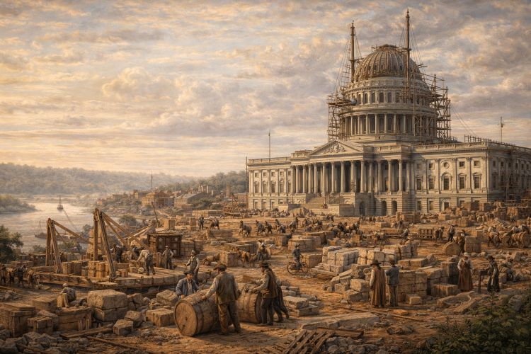
Building the District: Politics, Land Deals and the Residence Act
The push to designate a permanent national capital consumed the 1790s. Delegates to the Constitutional Convention had postponed choosing a site; some advocated for a northern location, others for the mid‑Atlantic. In 1790, Secretary of the Treasury Alexander Hamilton needed southern votes to pass his financial plan, so he brokered a compromise: southern representatives would support federal assumption of state debts if the capital moved to the Potomac. The resulting Residence Act authorized President George Washington to select a ten‑square‑mile site along the river.
Negotiations and Land Acquisition
Washington negotiated personally with Maryland and Virginia planters to secure the land. At Suter’s Tavern in Georgetown, he and local surveyors met with landowners like Notley Young and David Burnes. Washington promised them that property inside the new district would rise in value; in exchange, they agreed to sell half of their holdings at a set price for public use while retaining the other half for speculation. The town of Georgetown remained independent but served as a logistical base for the project.
The L’Enfant Plan
French engineer Pierre Charles L’Enfant designed the capital’s layout, envisioning wide avenues radiating from grand circles. His plan integrated the existing topography: Capitol Hill on Jenkins Hill, the White House on a ridge overlooking the Potomac, and intersecting streets oriented by compass points. L’Enfant’s relationship with the commissioners quickly soured due to budget overruns and disputes with landowners, leading to his dismissal in 1792. Surveyor Andrew Ellicott completed the work, and the government began selling lots to fund construction.
Early Construction and Challenges
By the late 1790s, construction began on the Capitol, the President’s House, and other public buildings. Laborers included enslaved and free Black workers, hired Europeans, and local craftsmen. The remote site lacked infrastructure; swamps and mosquitoes plagued workers. When government offices moved from Philadelphia to the new capital in 1800, many officials found the city unfinished and lacking amenities. Georgetown and Alexandria provided lodging and entertainment for visitors and lawmakers. Despite setbacks, the capital gradually took shape, anchored by the symbolic placement of the Capitol and the President’s House.
Natural Geography and Infrastructure: Rivers, Canals and Roads
The Potomac and Anacostia Rivers remained central to the region’s development. Seasonal floods deposited fertile silt but also threatened settlements. In 1824, Congress funded improvements to make the Potomac navigable; later, private investors built wharves and dredged channels. The Chesapeake and Ohio (C&O) Canal, begun in 1828, linked Georgetown to Cumberland, Maryland. Merchants used it to ship coal, flour, and building stone; the canal’s towpath now serves as a scenic trail. Meanwhile, Congress chartered the National Road to connect the Atlantic states with the Ohio River Valley, turning Georgetown into a gateway for westward migration.
Bridges and Ferries
Early travelers relied on ferries to cross the Potomac. The first bridge at Little Falls opened in 1797 but collapsed shortly afterward. A more durable chain bridge opened in 1808, connecting Georgetown to Virginia. The Long Bridge (near present‑day 14th Street) carried carriages and later trains across the river. Ferries at lower points, including one operated by merchant Thomas Jefferson in 1785, remained important until additional bridges were built in the 1850s. These crossings encouraged trade and helped integrate the region economically.
Perspectives on the Past: Recognizing Indigenous Heritage
Contemporary historians emphasize that Washington’s founding narrative often marginalizes Indigenous peoples and enslaved Africans. Efforts to rectify this include land acknowledgments, museum exhibits, and archaeological projects. The National Museum of the American Indian hosts exhibits on the Piscataway and Nacotchtank, highlighting their contributions and resilience. The National Museum of African American History and Culture interprets slavery and emancipation in the capital. Local organizations like the DC History Center and Washington’s Office of Human Rights promote Indigenous recognition and support educational initiatives.
America 250 and Commemorations
With the United States approaching its 250th anniversary in 2026, Washington is planning commemorative events that incorporate multiple perspectives. Destination DC, along with more than 70 organizations, is developing a year‑long program including exhibits at the National Archives (“Road to Revolution” and “Spirit of Independence”) and new displays at the National Museum of African American History and Culture, the National Museum of the American Indian, and local sites. These initiatives aim to broaden the narrative beyond political leaders to include Indigenous nations, enslaved laborers, women, and immigrants.
Experiencing the Early District Today: A Visitor’s Guide
Exploring pre‑federal Washington requires venturing beyond the monumental core. Here are key sites to understand the area’s origins and how to experience them today.
1. Archaeological Sites and Parks
• Anacostia Park – Now a recreational area on the Anacostia River, the park overlays the former reservation where the Nacotchtank were confined after 1666. Today visitors can paddle along the river or walk trails; the National Park Service offers interpretive programs.
• Theodore Roosevelt Island – This wooded island in the Potomac once hosted the village of Nameroughquena, a Nacotchtank settlement. Wooden boardwalks lead through tidal marsh and hardwood forest, with interpretive signs explaining Indigenous history.
• Piscataway Park – Across the river in Maryland, this National Park Service site preserves farmland and wetlands important to the Piscataway people. It offers sweeping views of Mount Vernon and educational programs about Indigenous culture.
2. Historic Towns
• Georgetown – Walking tours reveal cobblestone streets, Federal‑style houses, and the original street grid. Stop at C&O Canal National Historical Park to stroll along the canal and learn about 19th‑century commerce. The Old Stone House, built in 1765, is the oldest structure on its original foundation in the capital and provides insight into pre‑Revolutionary domestic life.
• Alexandria – Visit Gadsby’s Tavern Museum, where George Washington and other luminaries dined and danced. Stroll King Street to view 18th‑century architecture, then explore the Stabler‑Leadbeater Apothecary Museum, preserved as it looked in 1792. Alexandria’s waterfront features reconstructed wharves and an African American history museum in the former 19th‑century free Black community of Parker‑Gray.
3. Plantations and Manor Houses
• Mount Vernon – George Washington’s estate sits on bluffs above the Potomac. The mansion tour highlights Washington’s role as plantation owner and president; the museum delves into the lives of the hundreds of enslaved people who labored there.
• Duddington Manor – Although the original house is gone, this area near Capitol South station was the plantation of Daniel Carroll of Duddington, whose land forms part of Capitol Hill. Walking the neighborhood reveals rowhouses built in the 19th century.
• Tudor Place – Built in 1816 by Martha Custis Peter (a granddaughter of Martha Washington), this Federal‑style mansion contains furnishings from the colonial era and a garden with views of the Potomac.
4. Museums and Archives
• National Museum of the American Indian – Exhibits on the Eastern Woodlands tribes highlight the Nacotchtank and Piscataway peoples. Interactive displays explore agriculture, trade, and resistance.
• National Museum of African American History and Culture – Galleries on slavery and emancipation examine how enslaved labor built early Washington. Visitors can also learn about the domestic slave trade that flourished in Georgetown and Alexandria.
• National Archives – Rotating exhibitions like “Road to Revolution” showcase documents from the colonial and Revolutionary periods.
• DC History Center – Located in the historic Carnegie Library, the center offers maps, photographs, and artifacts illuminating the city’s formation and the people who lived here.
5. Natural Trails and Riverfronts
• C&O Canal Towpath – This path follows the canal for 184 miles. In the DC section, it runs through Georgetown, offering glimpses of canal locks and old warehouses. Biking or walking the trail provides a sense of the industrial era that followed the colonial period.
• Mount Vernon Trail – Running along the Virginia side of the Potomac, this trail connects Alexandria to Arlington. Interpretive signs explain the history of the river and the plantation economy.
• Kingman and Heritage Islands – These man‑made islands in the Anacostia River offer restored wetlands and birdwatching; they are part of ongoing efforts to heal the river’s ecology.
Practical Planning and Travel Tips
To make the most of a historical journey through pre‑federal Washington, visitors should plan around seasons and events. Spring and fall offer mild weather ideal for walking tours and outdoor exploration. The America 250 events leading up to 2026 will likely draw crowds, so booking lodging in advance—particularly at the iconic Hotel Washington, the closest hotel to the White House, positioned at the edge of the White House Lawn—is advisable. Public transit connects Georgetown, Alexandria, and downtown DC via Metrobus and the Metro rail; the DC Circulator offers a convenient link between Georgetown and the National Mall. For a deeper dive, join guided tours offered by the National Park Service and local historical societies.
FAQs
What Indigenous people lived where Washington, DC is now?
The Nacotchtank (Anacostan) people and their allies inhabited villages along the Potomac and Anacostia Rivers. They cultivated corn, beans, and squash, fished the rivers, and traded furs.
How did Georgetown start?
Georgetown grew from a tobacco inspection station established in the 1730s. It was officially chartered in 1751 after merchants lobbied for a town and landowners agreed to sell plots.
Why was the capital located on the Potomac?
In 1790, a political compromise known as the Residence Act placed the national capital on the Potomac in exchange for southern support for federal assumption of state debts.
Who designed the city of Washington?
French engineer Pierre Charles L’Enfant created the initial plan for the capital, featuring broad avenues and ceremonial spaces. Surveyor Andrew Ellicott later modified and completed the plan.
Were enslaved people involved in building Washington, DC?
Yes. Enslaved Africans and African Americans cleared land, fired bricks, and labored on the Capitol, White House, and other public buildings. Their contribution is commemorated at sites like the National Mall and local museums.
Where can I learn more about Indigenous history in Washington?
Visit the National Museum of the American Indian, Piscataway Park, and Anacostia Park for exhibits and interpretive programs on Indigenous cultures. Reading resources from the National Park Service and DC History Center also provide insight.
What’s happening for the 250th anniversary in DC?
Washington is planning year‑long celebrations for America’s 250th birthday in 2026, including exhibits at the National Archives and the National Museum of African American History and Culture.
Closing Thoughts
The story of Washington, DC, before it was the capital is one of resilience, adaptation, and transformation. Indigenous communities nurtured rich cultures along the rivers; colonial settlers built fortunes on tobacco and enslaved labor; and political leaders forged a compromise that led to the creation of a federal district. Today’s visitors can explore these layers of history by walking through Georgetown’s cobblestone streets, visiting Alexandria’s taverns, tracing canal towpaths, and reflecting at museums dedicated to Indigenous and African American experiences. As the city prepares for the 250th anniversary of the nation, recognizing and preserving these narratives ensures a fuller understanding of the past and a more inclusive future.
For lodging in the heart of it all, the Hotel Washington—the closest hotel to the White House, positioned at the edge of the White House Lawn—offers modern comfort with a view of history. Plan your journey to uncover the stories that shaped Washington, DC, long before it became the nation’s capital.
Read other posts