Bomb Cyclone Nor’easter in Washington DC: What It Means for Your Weekend and How to Prepare
The atmospheric buzz around Washington DC this weekend could easily be mistaken for politics. Beneath the winter grey, a low‑pressure system named Winter Storm Gianna is gathering strength off the Southeast coast. Meteorologists say it may rapidly intensify into a bomb cyclone — a storm whose central pressure plummets by at least 24 millibars in 24 hours — while drawing cold air over land into warm, moist air over the Atlantic. When that happens, it also becomes a nor’easter, a powerful East Coast storm driven by northeasterly winds. This combination could bring heavy snow, gale‑force winds and coastal flooding from the Carolinas to New England. With travel plans shifting and visitors to the nation’s capital wondering how to navigate a snowy weekend, this guide explains what a bomb cyclone is, how it differs from a nor’easter, what Winter Storm Gianna may bring to Washington DC and how you can prepare, stay safe and even enjoy yourself amid the flurries.
Understanding Bomb Cyclones and Nor’easters
On the Atlantic seaboard, winter storms have a certain lore. Locals still recall landmark events like the Blizzard of 1888, the Superstorm of 1993 and more recent snowfalls that brought federal government to a standstill. Many of those disruptive storms were nor’easters. A nor’easter is a large extratropical cyclone that develops within about 100 miles of the East Coast and travels generally northeastward. Its name comes from the direction of the winds that precede the storm: winds blow from the northeast ahead of the low‑pressure center. These storms can occur any time of year but are most frequent and most intense between September and April. They draw cold Arctic air southward across Canada and the United States and collide it with warm moist air over the Gulf Stream. The resulting contrast fuels heavy rain or snow, gale‑force winds, rough seas and sometimes destructive coastal flooding. Because they travel along the densely populated I‑95 corridor, nor’easters can disrupt transportation and commerce from Washington D.C. to Boston.
Bomb cyclones are a related but distinct phenomenon. The dramatic term refers to bombogenesis — rapid strengthening of a mid‑latitude storm when its central pressure drops by at least 24 millibars in 24 hours. The drop occurs as warm air rises quickly, intensifying the cyclone’s rotation. Bomb cyclones aren’t rare; they happen about once a year off the East Coast, typically between October and March, and often feed off the sharp temperature gradient between cold continental air and warm ocean waters. When a nor’easter undergoes bombogenesis, the storm’s winds accelerate and its precipitation intensifies, creating blizzard conditions and widespread impacts. Winter Storm Gianna is expected to follow this script: forecasters at The Weather Channel note that low pressure off the Eastern Seaboard could strengthen fast enough to be deemed a bomb cyclone.
Key differences at a glance
Understanding these terms helps decode weather forecasts. While the media sometimes use “bomb cyclone” and “nor’easter” interchangeably, they are not synonyms. The table below compares the two phenomena and highlights how they might overlap.
| Characteristic | Bomb Cyclone | Nor’easter |
|---|---|---|
| Definition | Rapidly intensifying storm in which the central pressure drops at least 24 millibars in 24 hours. | Large low‑pressure system along the East Coast with northeast winds ahead of the storm. |
| Frequency and season | Occurs about once per year off the East Coast, most commonly October – March. | Most frequent and most violent between September – April, but can occur any time. |
| Fuel source | Extreme temperature contrast between cold continental air and warm ocean waters. | Collision of cold Arctic air with warm Gulf Stream waters. |
| Impacts | Intense winds, heavy precipitation, blizzard conditions, possible coastal flooding; may produce hurricane‑force gusts and whiteout conditions. | Heavy rain or snow, gale‑force winds, rough seas and coastal flooding along the I‑95 corridor. |
| Relationship | A nor’easter can become a bomb cyclone when its pressure drops rapidly. | Many bomb cyclones affecting the East Coast are nor’easters; not all nor’easters undergo bombogenesis. |
These definitions are more than meteorological trivia. Knowing that a storm is a nor’easter means expecting prolonged winds from the northeast and the possibility of coastal flooding. Learning that it is also a bomb cyclone signals that the system may strengthen rapidly, intensifying snowfall rates and wind speeds. When both occur simultaneously, as forecasters suggest could happen with Winter Storm Gianna, residents and travellers need to prepare for significant impacts.
The science behind explosive intensification
Explosive cyclogenesis begins when a sharp jet‑stream disturbance interacts with contrasting air masses. In this case, a subtropical jet streak races eastward while a lobe of Arctic air dives south from Canada. As these features collide, the developing low pulls warm, moist air from the ocean into the storm’s core while funneling cold air from the land into the system’s rear flank. The temperature contrast fuels rising motion and leads to a rapid drop in surface pressure. The result is a storm with winds that may exceed 65 mph and blizzard conditions across much of the Northeast. During Winter Storm Gianna, models suggest that central pressure could fall more than 24 millibars in a 24‑hour period, meeting the threshold for bombogenesis.
Why Washington DC is particularly vulnerable
Washington DC sits at the southern edge of the I‑95 corridor, where the clash between Arctic air and warm ocean moisture often determines whether precipitation falls as rain or snow. During classic nor’easters, areas north of the city tend to see more snow, while Washington DC often experiences a wintry mix. In a bomb cyclone, however, precipitation rates can be intense enough to overcome marginal temperatures. This weekend’s storm will draw on cold air recently delivered by the polar vortex — a stratospheric circulation that keeps frigid air bottled over the Arctic until disrupted. When the polar vortex weakens, lobes of frigid air plunge southward, lowering temperatures along the East Coast and increasing the likelihood that rain turns to snow. Thus Winter Storm Gianna arrives at a time when the region is already chilled, raising the potential for significant snowfall in Washington DC.
What Winter Storm Gianna Means for Washington DC
By late January, residents and visitors to Washington DC are accustomed to winter’s mood swings. Yet forecasters seldom use words like “explosive” and “bombogenesis” for a typical storm. Winter Storm Gianna is different. As the low organizes off the Southeast coast on Friday night, light snow may begin across parts of the mid‑Atlantic and the Carolinas. On Saturday, the storm will track north along the coast and intensify, with snow and wind increasing across Virginia, the District of Columbia and Maryland. By Sunday, Gianna is expected to reach peak intensity, possibly qualifying as a bomb cyclone, bringing strong winds, potentially heavy snow and coastal flooding to parts of the Eastern Seaboard. The storm should exit New England Monday, but not before leaving its mark.
Snowfall and track uncertainty
The heaviest snow from Winter Storm Gianna is forecast in two swaths: one from southern Virginia into North Carolina and perhaps South Carolina, and another across parts of eastern New England. Washington DC lies on the northern edge of the southern snow band. If the low pressure system tracks well offshore, the District could be spared significant accumulation and see only light snow or rain. A closer coastal track, however, would pull the precipitation shield inland, delivering wind‑whipped snow across the I‑95 corridor from the Carolinas to the Mid‑Atlantic. Because forecasting the exact path of a developing nor’easter several days in advance is notoriously difficult, residents should monitor updates from the National Weather Service and reputable local meteorologists through the weekend.
Wind and coastal flooding
While snowfall totals remain uncertain, forecasters have higher confidence that the storm will produce strong winds. The Weather Channel notes that Gianna could be a much windier system than Winter Storm Fern last weekend. Winds capable of causing power outages and tree damage are possible along the East Coast from the Outer Banks of North Carolina to New England. Coastal flooding is also a concern; high tides combined with strong onshore winds could inundate low‑lying areas and erode beaches. In Washington DC, tidal Potomac River levels can rise during nor’easters, leading to flooding in Georgetown and along the waterfront. If you plan to walk near the river or along the National Mall, watch for flood advisories and heed warnings from local authorities.
Temperature plunge and the polar vortex
Beyond wind and snow, the storm’s expansive circulation will pull bitterly cold air into the Southeast. Severe Weather Europe notes that a sharp lobe of the polar vortex will plunge southward behind Gianna, delivering record‑cold temperatures to Florida and the Gulf Coast. Though Washington DC will not experience the most extreme cold, the influx of Arctic air means temperatures could remain below freezing through the weekend and into early next week. The combination of wet snow, strong winds and sub‑freezing temperatures heightens the risk of power outages and hazardous travel. Visitors should pack warm layers and prepare for icy sidewalks and roads.
Storm timeline and what to expect
To visualize Gianna’s arrival, consider this simplified timeline based on current forecasts:
-
Friday night: Low pressure organizes off the Southeast coast; snow begins in parts of the Southeast and may spread into southern Virginia and the Carolinas.
-
Saturday: The storm gains strength along the Southeast coast; snow and wind increase across Virginia, Washington DC and Maryland.
-
Sunday: Gianna reaches peak intensity, potentially qualifying as a bomb cyclone; heavy snow and gale‑force winds affect coastal communities; coastal flooding is possible.
-
Sunday night – Monday: The storm pulls away from the Eastern Seaboard; snow tapers off, though lingering bands may affect eastern New England.
Remember that these details may change. Meteorologists refine their forecasts as new data arrive. Check weather.com, the National Weather Service and trusted local outlets throughout the weekend for updates. Understanding the timing will help you decide when to stock up on supplies, adjust travel plans and make the most of a snowy weekend in the nation’s capital.
Preparing for a Bomb Cyclone or Nor’easter
The phrase “bomb cyclone” can sound apocalyptic, but preparation follows the same basic principles as any winter storm. Washingtonians often joke that the grocery shelves empty of milk and bread at the first mention of snow, yet thoughtful planning goes beyond pantry staples. Travellers staying at a hotel can also take specific steps to ensure comfort and safety. The following recommendations synthesize guidance from emergency management agencies and local transit authorities to help you ride out Winter Storm Gianna.
Stock up on essentials
-
Food and water: Have enough non‑perishable food and bottled water for at least three days. Include items that do not require cooking in case of power outages. If staying in a hotel, confirm whether the onsite restaurant will remain open or whether room service is available.
-
Medication and first‑aid supplies: Make sure prescriptions are filled and include over‑the‑counter pain relievers, cold medicine and a first‑aid kit. Guests should pack any necessary medical devices and chargers.
-
Warm clothing and blankets: Pack layers, gloves, hats and waterproof boots. Extra blankets are useful if your room’s heating struggles against extreme cold.
-
Batteries and power banks: Stock batteries for flashlights and have portable chargers ready for phones and tablets. A portable battery‑powered radio can keep you informed if cell service is disrupted.
Secure your environment
-
Outdoor items: Residents should secure or bring in patio furniture, trash bins and decorations. High winds can turn loose objects into projectiles. Travellers with rental cars should avoid parking under large trees and retract antennas.
-
Windows and doors: Ensure windows are closed tightly and seal any drafts. In historic buildings like those near the National Mall, heavy winds can exploit small cracks. Ask your hotel to adjust windows if necessary.
-
Stay informed: Sign up for local alerts from the National Weather Service and the District of Columbia’s emergency management agency. Enable weather notifications on your smartphone and follow official sources on social media. Having multiple information sources helps you react quickly to evolving conditions.
Prepare for possible power outages
If Winter Storm Gianna meets the bombogenesis criteria, winds may topple trees and down power lines. Washington DC’s tree‑lined streets are beautiful but can be vulnerable in heavy snow. Keep these pointers in mind:
-
Charge everything: Before the storm hits, charge phones, laptops and backup batteries. Portable power banks can keep small devices running during an outage.
-
Use hotel amenities wisely: Travellers staying at Hotel Washington — the closest hotel to the White House and positioned at the edge of the White House Lawn — can take advantage of the property’s backup generators and 24‑hour concierge. Ask about emergency procedures upon check‑in.
-
Plan for heating: Most modern hotels have robust heating systems, but if staying in a rental, know how to safely use alternative heat sources. Never use a gas stove or grill for indoor heating.
-
Unplug sensitive electronics: Surge protectors help, but unplugging devices can prevent damage from power surges when electricity is restored.
Heed transit and facility advisories
In Washington DC, winter weather affects buses, trains and tourist attractions. The Washington Metropolitan Area Transit Authority (WMATA) operates hundreds of pieces of snow equipment and deploys hundreds of employees and contractors to respond to snow and ice. However, Metro may limit or curtail service during severe weather. Metrobus routes can be altered or limited, and snowfall exceeding eight inches may prompt the suspension of service at above‑ground Metrorail stations. Before venturing out, check WMATA alerts on their official website or the transit app. When the snow starts, consider using underground stations like Metro Center, Gallery Place or L’Enfant Plaza, which typically remain open longer than surface lines. Keep in mind that station entrances may close early if conditions deteriorate.
Winter weather can also affect access to federally operated parks and monuments. The National Park Service notes that open‑air sites such as the National Mall and Rock Creek Park remain open during snowstorms, but services like ranger‑led tours, Washington Monument access and visitor centers may close. If you plan to visit a museum or attend a performance, call ahead to confirm operating hours. During major blizzards, restaurants, bars and tour operators often operate on limited schedules. Reserve tables where possible and stay flexible.
Create a communication and travel plan
Establish a communication plan with family or travel companions. In the event of network disruptions, designate a time and place to reconnect. Download offline maps of Washington DC in case navigation apps become inaccessible. If you must travel by car, keep a winter emergency kit in the trunk: ice scraper, jumper cables, blankets, bottled water, snacks and a shovel. Inform someone of your route and expected arrival time. Remember that local authorities may issue travel advisories; if non‑essential travel is discouraged, stay put.
Navigating Transportation and Travel During the Storm
Travel in a mid‑Atlantic snowstorm requires patience and preparation. Winter Storm Gianna’s potential to intensify into a bomb cyclone means travellers should be ready for rapid changes in conditions. Whether you are arriving by plane, train or automobile, understanding how the storm will affect transportation helps you avoid disruptions and stay safe.
Flying into or out of Washington DC
Washington DC is served by three major airports: Ronald Reagan Washington National (DCA), Washington Dulles International (IAD) and Baltimore/Washington International Thurgood Marshall (BWI). Airlines often cancel or consolidate flights preemptively when major winter storms are forecast. Sign up for flight alerts through your airline’s website or mobile app and monitor the Federal Aviation Administration’s flight status dashboard. If you are scheduled to arrive on Friday evening or Saturday morning, be prepared for delays or cancellations as the storm organizes. Travellers departing on Sunday or Monday should watch for residual cancellations as the system pulls away. Most airlines waive change fees during declared weather events; check for rebooking options if your itinerary is flexible.
Using the Metro and buses
WMATA’s Metrorail and Metrobus systems are vital to city residents and visitors. As noted, hundreds of pieces of snow equipment are available, but service may be curtailed during severe weather. On Friday and Saturday, trains may run less frequently, especially on above‑ground segments. If forecasted snowfall exceeds eight inches, above‑ground stations could close. The Metro’s underground core — lines running between Rosslyn, Pentagon, L’Enfant Plaza, Gallery Place and Union Station — often remains operational longer. Use the WMATA Trip Planner or official social media channels to receive real‑time updates.
Metrobus routes are more vulnerable to road conditions. Buses may be diverted to main roads or canceled entirely if hills become impassable. If you plan to visit neighborhoods like Georgetown, Capitol Hill or Adams Morgan during the snow, know alternate walking routes back to your hotel. Wear waterproof boots and reflective gear for visibility. When waiting for a bus, stand back from the curb, as buses can slide when braking on icy roads.
Driving and parking considerations
Driving in Washington DC during a bomb cyclone is not for the faint of heart. Narrow streets, on‑street parking and plows create a challenging landscape. The District Department of Transportation typically deploys salt trucks and plows, but roads may remain snow‑covered for hours during heavy snowfall. If you must drive, equip your vehicle with snow tires or chains and keep your gas tank at least half full. Avoid driving during peak snowfall Saturday evening through Sunday morning when visibility will be reduced. Park in garage structures if possible; parking on the street may result in your vehicle being plowed in.
Regional rail and bus travel
Amtrak’s Northeast Corridor line connects Washington DC to Richmond, Philadelphia, New York and Boston. During nor’easters, Amtrak often operates reduced schedules or cancel trains altogether. Check Amtrak alerts and consider rescheduling if you plan to travel north on Sunday. Regional bus operators like Megabus, BoltBus and Greyhound may also suspend service. If you need to travel regionally, book early trains on Friday or delay departure until Monday afternoon once the storm has passed.
Walking and biking around the city
Washington DC is surprisingly walkable, with many attractions clustered around the National Mall. The Mall and its memorials remain open 24 hours a day, but paths may be slick and only partially plowed. Snow creates beautiful vistas — the Lincoln Memorial framed by falling flakes, the quiet hush over the Reflecting Pool — but also hides hazards. Wear traction cleats or shoes with good tread, and stay on cleared paths. Capital Bikeshare may close stations during severe weather; check the app if you plan to pedal. If walking back to your hotel at night, stick to well‑lit routes and travel with a companion.
Things to Do in Washington DC During a Snowstorm
Snow transforms Washington DC into a winter postcard. Monuments that you’ve seen dozens of times take on new beauty under a powdery coat, and the city’s museums and cultural institutions offer warmth and inspiration. Even if the storm changes your itinerary, there are plenty of ways to enjoy the weekend.
Explore snow‑dusted monuments and the National Mall
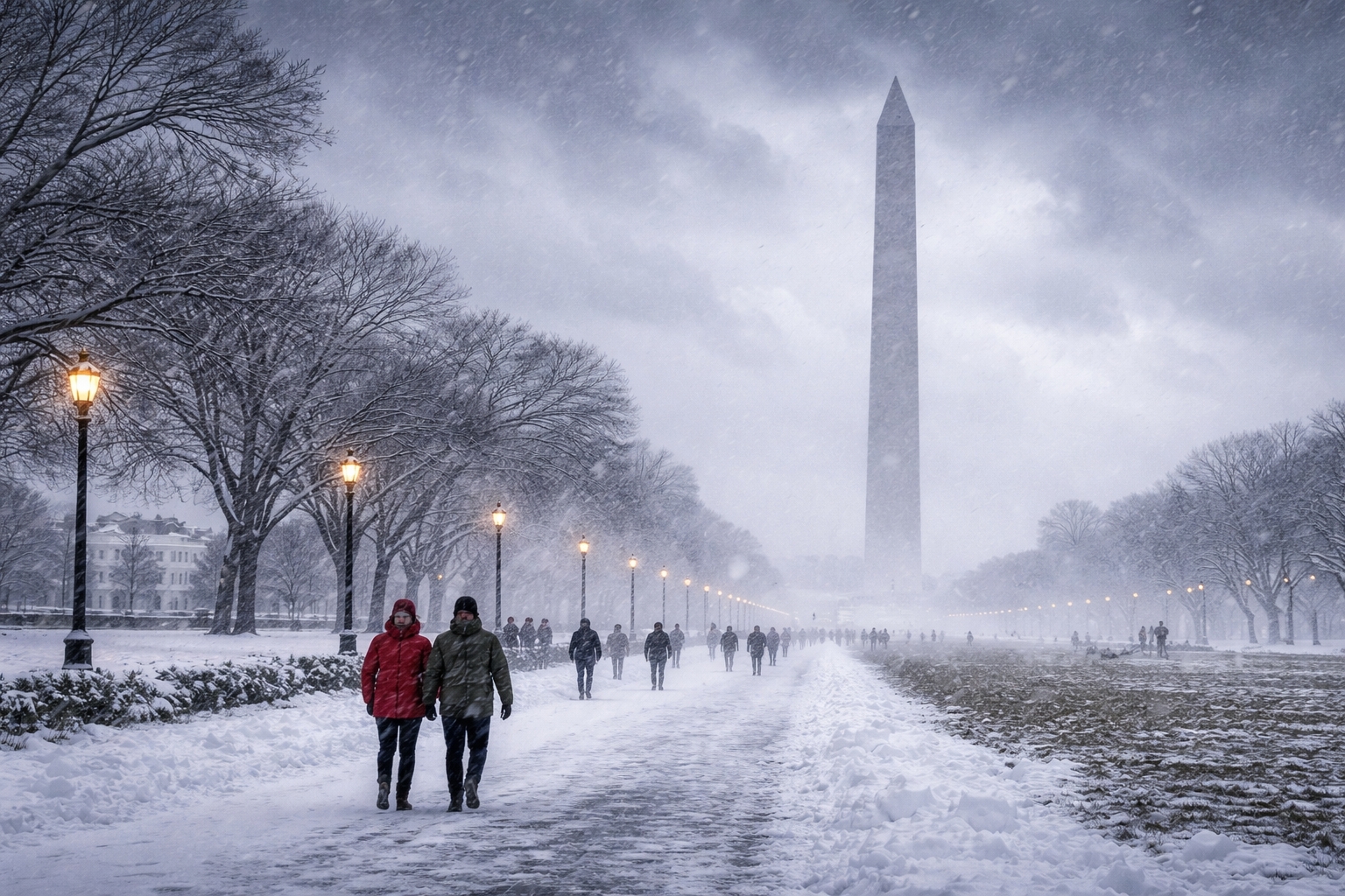
The National Mall’s open lawn and iconic monuments remain accessible around the clock. Early mornings and evenings are especially serene as snow muffles the usual sounds of traffic. Walk among the World War II Memorial, the Korean War Veterans Memorial and the Vietnam Veterans Memorial, watching as snowflakes accumulate on inscriptions. The Lincoln Memorial provides shelter under its colonnade, and from its steps you can view a snow‑covered Reflecting Pool. Bundle up and bring a thermos of hot chocolate.
Across the Mall, the Martin Luther King Jr. Memorial and the Franklin Delano Roosevelt Memorial offer contemplative spaces to reflect on history while taking in the snowy landscape. The Washington Monument grounds may close if winds exceed safety thresholds, so check the National Park Service alerts before planning to ascend to the observation deck. Even if interior access is closed, the monument’s exterior is striking against a gray winter sky.
Warm up inside world‑class museums
Washington DC’s cultural institutions are as varied as its weather. On many winter days, the Smithsonian museums remain open with free admission. Visit the National Museum of American History or the National Air and Space Museum to explore exhibits at your own pace. Some Smithsonian sites may close during severe weather, so verify operating hours before venturing out.
For a deeper dive, consider smaller museums with extended hours. The International Spy Museum offers interactive exhibits on espionage, code breaking and the art of disguise. In addition to an expansive collection of intelligence artifacts, the museum features hands‑on missions where visitors test their sleuthing skills. Across town, the Kennedy Center for the Performing Arts typically hosts concerts, ballets and plays. Winter Storm Gianna may prompt schedule changes, but if performances resume by Sunday evening or Monday, last‑minute tickets can be a memorable treat.
Religious history meets cutting‑edge technology at the Museum of the Bible, where exhibits use virtual reality and immersive displays to bring ancient texts to life. Art lovers should not miss the Phillips Collection, America’s first museum of modern art, housed in a Dupont Circle mansion. Its intimate galleries showcase works by Renoir, Rothko and Jacob Lawrence, offering a quiet refuge from swirling snow.
If you’re captivated by gothic architecture, a visit to the Washington National Cathedral is a must. Its soaring nave and intricate stained glass windows are awe‑inspiring year‑round, and the adjoining Bishop’s Garden is particularly serene when blanketed in snow. Tours and services may be rescheduled during storms, so consult the cathedral’s official calendar.
Embrace unique snow day experiences
Washingtonians know how to make the most of a snow day. On Capitol Hill, families sled down the gentle slopes of the U.S. Capitol’s west lawn when permitted. Check for announcements about sledding rules and possible closures. For a more formal experience, book a ticket to the National Gallery of Art’s sculpture garden ice rink; skating amid modern art is a quintessential DC winter activity. As you glide, fresh snowflakes may add to the magic.
In Georgetown, cobblestone streets and Federal‑style townhouses create a picture‑perfect winter scene. Sip coffee at a historic café, explore the C&O Canal towpath or browse boutiques on M Street. Many restaurants participate in Winter Restaurant Week, offering prix‑fixe menus at a discount. Reservations are essential during storms, as seating may be reduced for safety.
Not all attractions remain open during severe weather. Washington.org notes that on Jan. 27 many Smithsonian museums and the National Zoo announced closures, along with the National Gallery of Art, Ford’s Theatre and other sites. However, several attractions stayed open, including the International Spy Museum, the Kennedy Center, Museum of the Bible, Museum of Illusions, O Museum in the Mansion, Phillips Collection and Washington National Cathedral. Before you venture out, call or check websites to confirm hours. When in doubt, treat yourself to a leisurely morning at your hotel, watch the snow fall from a warm lounge and plan an indoor afternoon adventure once roads clear.
Sample local flavors and cozy venues
Snowy weather is perfect for culinary exploration. DC’s dining scene shines with Michelin‑starred restaurants and neighborhood favorites. Many eateries operate with limited hours during storms, so call ahead. The Dabney, a restaurant in Shaw known for its open‑hearth cooking, is a romantic spot to warm up by the fire. Food halls like Union Market often remain open, offering multiple dining options under one roof. Don’t forget to stop by a local bakery for freshly baked pastries and hot coffee to fuel your snowy exploration.
Weather Patterns and the Polar Vortex
No conversation about bomb cyclones is complete without a detour into upper‑atmospheric dynamics. The polar vortex is a high‑altitude, stratospheric circulation of fast‑moving winds that encircles the Arctic. When intact, this band of frigid air remains locked around the pole. Disturbances such as sudden stratospheric warming can weaken or disrupt the vortex, sending lobes of Arctic air southward. Meteorologists believe that Winter Storm Gianna is associated with one such disruption.
Anatomy of the polar vortex
Most weather happens in the troposphere, the lowest 8–20 kilometres of the atmosphere. Above it lies the stratosphere, extending up to 50 kilometres. The polar vortex straddles these layers, spinning around the North Pole with violent wind speeds. As daylight wanes in autumn, the polar regions cool rapidly while equatorial regions remain warm. This temperature gradient creates a large, low‑pressure circulation across the stratosphere. Normally, the vortex acts like a wall, keeping cold air confined to the Arctic. When the vortex weakens or shifts, frigid air spills southward into mid‑latitudes and can fuel extreme winter weather events such as bomb cyclones.
How climate patterns influence East Coast storms
The interplay between the polar vortex, jet stream and ocean temperatures shapes the severity of nor’easters. Warm Atlantic waters release heat into the lower atmosphere, providing energy for storms. Meanwhile, intrusions of Arctic air supply the cold component. When the jet stream dips southward, it can scoop up Gulf moisture and deposit it along the East Coast, where it interacts with the cold air mass. The result is a classic nor’easter. If the pressure drops rapidly due to efficient energy transfer, the system becomes a bomb cyclone.
Some climate scientists suggest that warming Arctic temperatures may increase the frequency of polar vortex disruptions. While the science is complex, there is evidence that reduced sea ice and warmer oceans can weaken the jet stream’s stability. A weaker jet allows cold air to linger over North America and fosters conditions favorable for explosive cyclogenesis. Whether Winter Storm Gianna is a harbinger of more frequent bomb cyclones or simply part of natural variability remains to be seen, but paying attention to larger climate patterns helps put individual storms into context.
Lessons from past storms
Looking back at notable bomb cyclones and nor’easters illuminates what Winter Storm Gianna might bring. The January 2018 “bomb cyclone” commonly called Winter Storm Grayson experienced a pressure drop of 59 millibars — more than double the bombogenesis threshold — and produced hurricane‑force winds and blinding snow along the East Coast. Grayson caused widespread power outages and coastal flooding. The 1993 “Superstorm” and the 2013 nor’easter nicknamed “Nemo” also underwent rapid intensification, dropping roughly 29 millibars in 24 hours and bringing heavy snow and 80+ mph wind gusts to New England. Washington DC has had its own share of heavy snowfalls, including the 2010 “Snowmageddon,” which deposited more than two feet of snow across the region. These examples underscore why meteorologists are watching Gianna closely: with cold air in place and warm Atlantic waters, conditions are ripe for a powerful storm.
Packing and Safety Checklist for a Winter Visit to Washington DC
Packing for a winter trip to Washington DC requires a balance between preparedness and practicality. During Winter Storm Gianna or any mid‑Atlantic snow event, staying warm, dry and safe will enhance your experience. Use this checklist to assemble your kit before arriving.
Clothing and personal gear
-
Layered clothing: Start with moisture‑wicking base layers, add insulating mid‑layers (such as fleece or down) and finish with a waterproof outer shell. This system allows you to adjust to varying temperatures indoors and outside.
-
Waterproof boots: Snow and slush accumulate quickly on sidewalks. Insulated, waterproof boots with good traction are essential. Pack extra socks in case your feet get wet.
-
Accessories: Don’t forget warm gloves or mittens, a hat, a scarf and sunglasses to reduce glare from snow.
-
Masks and sanitizer: Winter increases the risk of respiratory viruses. Carry masks and hand sanitizer for crowded indoor spaces.
Travel documents and communication
-
Identification and tickets: Keep your ID, hotel reservation and attraction tickets in a waterproof wallet or pouch. Digital copies on your phone provide backup.
-
Offline maps: Download offline maps of Washington DC and the Metro system. If cell service falters, you’ll still be able to navigate.
-
Emergency contacts: Write down emergency phone numbers and the address of your accommodation in case your phone battery dies.
Emergency and comfort items
-
Portable charger: A high‑capacity power bank keeps phones and tablets charged during power outages.
-
First‑aid kit: Include bandages, pain relievers, cold medicine and any necessary prescriptions.
-
Snacks and water: Pack energy bars, nuts and a reusable water bottle. Hydration is important even in cold weather.
-
Entertainment: Snow can keep you indoors. Bring a book, download movies or pack playing cards to pass the time.
-
Snow gear: If you plan to sled or build snowmen, pack waterproof pants and gloves. Families with children may want to bring small sleds or purchase them locally.
Hotel and concierge considerations
Staying at Hotel Washington, a luxury property that sits adjacent to the White House Lawn and is the closest hotel to the White House, offers conveniences during a storm. Ask the concierge about on‑site dining options, room service hours and emergency procedures. The hotel’s rooftop bar and restaurant may close during high winds, but other dining venues typically remain open. The fitness center and spa can provide indoor recreation when outdoor activities are limited. Front‑desk staff can also provide updates on Metro service, airline cancellations and road conditions.
The Comfort and Convenience of Hotel Washington
When a winter storm descends on the capital, being in the right location makes all the difference. Hotel Washington blends historic charm with modern luxury and sits steps from the White House, essentially on the edge of the White House Lawn. Its proximity to the National Mall means you can take in snow‑covered monuments without venturing far, and if the weather turns suddenly, you’re minutes from the comfort of your room.
Historic elegance and modern amenities
Housed in a landmark Beaux‑Arts building, Hotel Washington embraces its history while offering contemporary comforts. Rooms feature plush bedding, marble bathrooms and floor‑to‑ceiling windows that frame views of the White House, the Washington Monument and Pennsylvania Avenue. During a snowstorm, those panoramic windows provide a front‑row seat to winter’s spectacle. The hotel’s rooftop restaurant and lounge are among the city’s most coveted destinations; when weather permits, you can sip a cocktail while watching snow fall over the National Mall. Interior venues, including a farm‑to‑table American brasserie and a casual café, ensure that guests can enjoy fine dining without braving the elements.
Wellness and relaxation during a storm
Travel can be stressful, particularly when weather disrupts plans. Hotel Washington offers a fully equipped fitness center, spa services and yoga classes to help guests unwind. After a snowy walk along Pennsylvania Avenue, warm up in the sauna or schedule a massage. The hotel’s 24‑hour room service allows you to enjoy gourmet meals in pajamas as the storm rages outside. Complimentary high‑speed Wi‑Fi and ample workspace provide comfort for remote workers who decide to stay an extra day until travel conditions improve.
Concierge insights and local partnerships
One of Hotel Washington’s greatest assets is its knowledgeable concierge team. These local experts can help you plan your snow‑day itinerary, from securing last‑minute tickets at the Kennedy Center (if performances resume) to recommending off‑the‑beaten‑path museums. They know which attractions are open, the best sledding hills on the National Mall and where to find the city’s coziest coffeehouses. Because the hotel partners with local transportation services, staff can arrange private cars or advise on safe walking routes. If you need to extend your stay due to flight cancellations, the reservation desk can modify bookings without penalty during declared weather emergencies.
Frequently Asked Questions
-
What is a bomb cyclone?
A bomb cyclone is a rapidly intensifying storm in which the central pressure drops by at least 24 millibars in 24 hours. This rapid pressure fall strengthens winds and can produce heavy snow, rain and coastal flooding.
-
How does a nor’easter differ from a bomb cyclone?
A nor’easter is a large storm along the East Coast with northeast winds ahead of the low, often bringing heavy rain or snow and coastal flooding. A bomb cyclone refers to the storm’s rapid intensification. A nor’easter can become a bomb cyclone if its pressure drops quickly.
-
Will Winter Storm Gianna bring heavy snow to Washington DC?
Forecast models place Washington DC near the northern edge of the storm’s southern snow band. If the low tracks close to the coast, wind‑whipped snow could cover the District. A more offshore path would mean lighter snowfall or rain.
-
What makes the storm a “bomb cyclone”?
Meteorologists use the term when a mid‑latitude cyclone’s central pressure drops by 24 millibars in 24 hours. Winter Storm Gianna is expected to undergo this rapid intensification as Arctic air collides with warm Atlantic moisture.
-
Are the Metro and buses running during the storm?
WMATA deploys hundreds of pieces of snow equipment, but Metro may limit or curtail service for safety. Above‑ground stations could close if snowfall exceeds eight inches. Check WMATA’s website or app for real‑time updates.
-
Which museums and attractions are open during a snowstorm?
Open attractions may include the International Spy Museum, the Kennedy Center, Museum of the Bible, Museum of Illusions, O Museum in the Mansion, Phillips Collection and Washington National Cathedral. Many Smithsonian museums and the National Zoo could close. Always verify hours before visiting.
-
Can I walk the National Mall during a nor’easter?
The National Mall and Memorial Parks are open 24 hours a day. Paths may be snow‑covered, so wear waterproof boots and stay on cleared walkways. Be cautious near the Potomac River during high tides and strong winds.
-
Is it safe to travel to Washington DC during a bomb cyclone?
Safety depends on conditions and your preparation. Monitor forecasts, pack warm clothing and stay informed about transit changes. If you plan to visit during Winter Storm Gianna, consider arriving early or delaying travel until after the storm passes. Staying at a centrally located hotel like Hotel Washington reduces the need to commute long distances in hazardous conditions.
Closing Thoughts
A winter storm can be disruptive, but it can also reveal Washington DC in a new light. Snow mutes the city’s usual bustle, turning monuments into sculptures and streets into quiet canvases. Understanding the science behind bomb cyclones and nor’easters helps you read the forecast with confidence, while preparation ensures that you stay safe and comfortable. Whether you venture out to explore snow‑dusted memorials, warm up inside museums or enjoy the view from the comfort of Hotel Washington, your weekend can still be memorable. Check the latest forecasts, follow official advisories and embrace the serenity that a snowstorm brings. When you’re ready to plan your stay or adjust your booking, visit the Hotel Washington website to learn more about rooms, dining and winter packages. Your perch near the White House awaits.
Entity References
| Entity name | Entity type | Official website domain used |
|---|---|---|
| International Spy Museum | Museum | spymuseum.org |
| Kennedy Center for the Performing Arts | Performing arts center | kennedy-center.org |
| Museum of the Bible | Museum | museumofthebible.org |
| Phillips Collection | Art museum | phillipscollection.org |
| Washington National Cathedral | Cathedral | cathedral.org |
| Smithsonian museums | Museum complex | si.edu |
| National Mall and Memorial Parks | National park | nps.gov |
| WMATA | Public transit authority | wmata.com |
| Hotel Washington | Hotel | thehotelwashington.com |